Delta 4 Poised to Launch with Next Generation GPS Satellite

Ken Kremer for NASA WATCH 21 May 2010, Kennedy Space Center

The launch of a Delta 4 rocket carrying the first in a new series of next generation GPS satellites has been rescheduled for Sunday night (May 23) at 11:17 PM EDT from Cape Canaveral, Florida after the countdown was halted barely 4 minutes prior to liftoff, shortly before midnight on Friday (May 21).

The last minute countdown scrub was called after loss of "the telemetry signal between the GPS and the satellite ground support equipment," according to a statement issued by the Air Force and United Launch Alliance (ULA).

Sunday's launch window runs from 11:17 to 11:35 PM EDT. The weather forecast predicts a 70 percent chance of favorable conditions.

May 2010 marks the 50th anniversary of the Delta program. The first Thor-Delta launched on 13 May 1960.

"This will be the 349th Delta launch. Overall, the Delta family of expendable rockets has a 95.7% success rate. Delta 4 was a 100% success rate since starting 8 years ago," said Bill Cullin, the Delta Launch Director for ULA at Pad 37.

The GPS IIF-1 satellite is the first in an advanced series of 12 satellites funded by the US Air Force which will provide highly accurate, three dimensional position, navigation and timing information on a 24/7 basis in all weather conditions. The spacecraft serve both military and civilian purposes.

The 330 ft tall mobile launch gantry was retracted from around the rocket early Friday morning. Media including myself visited Launch Complex 37 shortly thereafter at noon for a photo op.

See my photo gallery below of the Delta 4 rocket poised at Pad 37.

Watch for my post launch report.


Delta 4 rocket poised to launch on May 23 at 11:17 PM EDT from Space Launch Complex 37 at Cape Canaveral Air Force Station, Florida. Credit: Ken Kremer


Close up of Delta rocket with 4 meter composite payload fairing surrounding GPS IIF-1 navigation satellite. Credit: Ken Kremer


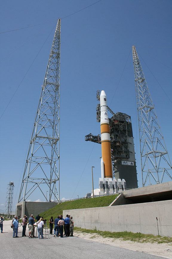
Media visit on May 21 to Delta 4 rocket astride fixed umbilical tower, lightening towers and flame trench. Credit: Ken Kremer


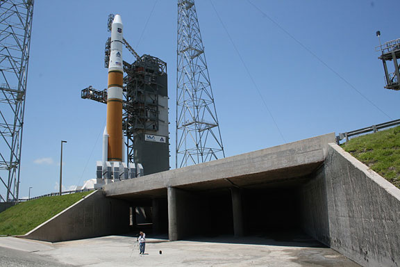
The Delta 4 rocket sits atop flame trench. Nearly a million pounds of thrust will be exhausted through the ducts at liftoff towards photographers location. Credit: Ken Kremer


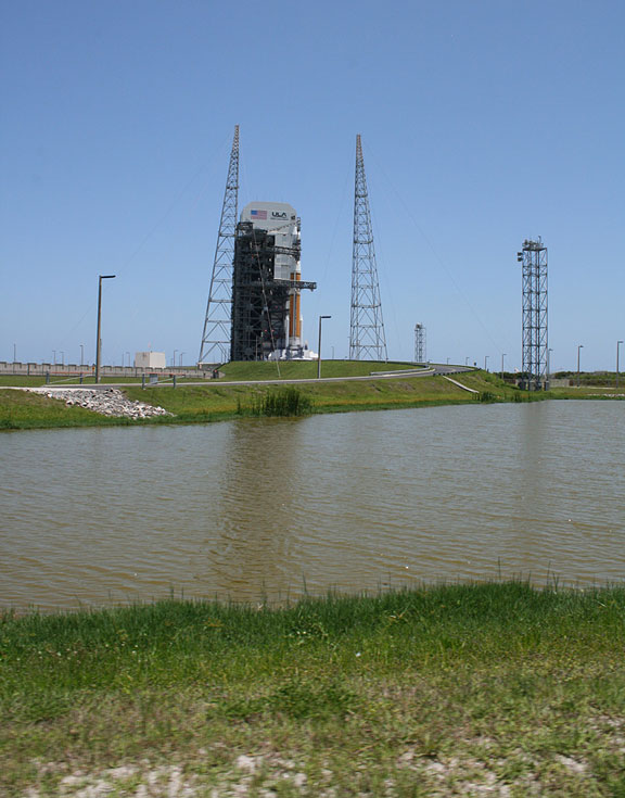
Launch Complex 37 with Delta 4 rocket at Cape Canaveral Air Force Station, Florida. Credit: Ken Kremer


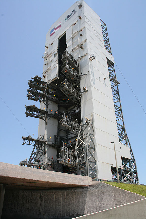
Mobile Service Tower at Complex 37 with swing arms open was retracted from Delta 4 rocket on the morning of May 21, 2010. Gantry sits atop flame trench. Credit: Ken Kremer


Ken Kremer on top of Launch Complex 37 with mighty 212 ft tall Delta 4 rocket which will fly in the Medium+ (4,2) configuration with two 65 ft long solid rocket motors. Credit: Ken Kremer


credit:www.spaceref.com

Bing versus Google Maps: Voice navigation compared

Comparing Bing and Google's voice nav
We tested Bing's voice navigation alongside Google's Android offering.
(Credit: CNET)
We've been using Google's voice-guided driving directions on an Android phone since October, but we didn't have too many equivalent apps to compare it with until Microsoft released its own voice navigation service for Bing last week for Windows phones.
We took Bing on a few test drives against Google's map navigation, all in the San Francisco Bay Area. Both apps will likely eventually get you where you want to go, but both exhibited overly creative directions and produced their own frustrating errors.
What we liked
We immediately noticed Bing's less tinny-sounding directions bot. Sure, "she" still sounds robotic, but less so than Google's navigatrix. We also appreciated how the Bing app "bings" before sounding off the next direction. The chime was a natural and unintrusive interruption to signal that voice guidance is imminent. It would have been nice if Bing also chimed to indicate that it's time to make a left or right turn, as Magellan's GPS units do, but that's a more minor quibble.
What we didn't like
Bing was the more navigationally flawed app in our tests compared with Google's navigation. Google's maps also have more features and options; for example, a street-level and bird's eye perspective of the map.
Within our first two test runs, Bing thrice dispensed misdirections that didn't correlate to the real world, including directing us to circle around a neighborhood even when we were on the same street as the destination address. There were also more trivial directional errors that turned up in subsequent testing.
We should note that commercial GPS navigators also run into the same pitfalls we noticed with Bing's navigation--like offering directions too early or too late and temporarily dropping GPS fixes (specifically within urban canyons)--so we can't dump all our blame on Bing, especially for issues that actually generate from the hardware and environmental access to GPS signal, and not from the software itself.

What else Google does better than Bing
On an absolute basis, we prefer Google Maps navigation to Bing's naviagion for its more faithful directions and more numerous map views, but also for its interface design. It's not exactly a fair fight. Specs-wise, the HTC Incredible on which we tested Google's Android-enabled navigation outclasses the Windows Mobile HTC Pure loaded with Bing. Yet  resolution and screen size aside, Google's navigation visuals--with its sharper corners, larger characters, and higher-impact color palette--provide an easier-to-read experience that's essential for drivers who might glance at the app to get their bearings.
Although Bing has a ways to go to catch up to Google's overall quality, if you've got a Windows phone, the "pro" of free voice navigation outweighs the service's cons. As with similar voice guidance software, Bing fetches directions after you add an address or location, pick a place on a map, select from favorite locations, and choose destinations-by-address book contacts--and it'll automatically reroute if you've missed a turn.
Just take Bing's voice guidance, like all navigation units, with a grain of salt.

Air Force: Tests didn't include troubled GPS unit

DENVER —

The Air Force says it performed no advance testing on the specific type of military GPS receiver that had problems picking up locator signals after a change in ground-control software.

The Air Force said Monday that it performed tests on other equipment, but none of it contained the type of receiver that was unable to lock on to GPS:Global Positioning System satellites after the change.

The manufacturer of the receivers, Trimble Advanced and Military Systems, says it did run advance tests and found no problems.

An Air Force spokesman says its testers didn't have any samples of the affected receiver. He says the Air Force is now acquiring a more representative sample of GPS receivers that are in use.

The problem occurred in January, and the Air Force says it has been fixed.

Google confesses it collected Wi-Fi data

The admission, made in an official blog post by Alan Eustace, Google's engineering chief, comes a month after regulators in Europe started asking the search giant questions about Street View, the layer of real-world photographs accessible from Google Maps.
Regulators wanted to know what data Google collects as its camera-laden cars methodically troll through neighborhoods, and what Google does with that data.

Google appears to have acted quickly after the questions were raised. Two weeks ago, Google said it did collect certain kinds of data around the world that identify Wi-Fi networks to help improve its mapping products.
The data on wireless networks can be used for advertising services for mobile phones, which can be pinpointed via a wireless network even if they lack a GPS chip. But the company said it did not collect or store “payload data” — the information being transmitted by users over unprotected networks.
In a confession made Friday that is sure to raise questions about its privacy policies, Google said that its claims were wrong.
Eustace wrote that a review of the Street View software has revealed that due to a programming error in 2006, the company has been mistakenly collecting snippets of data that happened to be transmitted over non-password protected Wi-Fi networks that the 

Google camera cars were passing. This occurred in Europe, in the United States and in other major cities elsewhere.
Eustace tried to play down the revelation, saying that Google “never used that data in any Google products.”
Google said it has temporarily halted its Street View cars and will stop collecting Wi-Fi data. Eustace said Google wants to delete the data, in cooperation with regulators, as soon as possible.
But the revelation is likely to set off a firestorm of protest and possibly new legal problems. Google could be accused of intercepting private communications and violating wiretap laws in the United States

Credit: By BRAD STONE New York Times


Darth Vader Offers His Voice For TomTom GPS Units

Ever wished your GPS gave you more entertaining voice commands while you were driving to your destination? Perhaps that voice could be your favorite character from your favorite movie? VoiceSkins.com -- who brought you celebrity voices from Homer Simpson of The Simpsons and rapper Snoop Dogg -- in partnership with TomTom GPS, Lucas Film and the Rebel Alliance, has released the official Star Wars voices.

The voice of android C-3PO is set to be released in July and Hans Solo's in August. Fans can already download Darth Vader's voice commands on the TomTom Web site for $12.95, while Star Wars-themed start-up screens, sounds and car icons are offered for free.


Below are some outtakes of the recording session with Darth Vader himself:

Darth Vader’s VoiceSkin is the first Star Wars GPS voice to be made available for download by users of TomTom GPS navigation systems.
Users can download Vader's voice for their units at VoiceSkins.com.

credit:
www.ballerstatus.com

Stem cells use GPS to generate proper nerve cells

An unknown function that regulates how stem cells produce different types of cells in different parts of the nervous system has been discovered by Stefan Thor, professor of Developmental Biology, and graduate students Daniel Karlsson and Magnus Baumgardt, at Linköping University in Sweden. The results improve our understanding of how stem cells work, which is crucial for our ability to use stem cells to treat and repair organs. The findings are publishing next week in the online, open-access journal PLoS Biology.

Stem cells are responsible for the creation of all cells in an organism during development. Previous research has shown that stem cells give rise to different types of cells in different parts of the nervous system. This process is partly regulated by the so-called Hox genes, which are active in various parts of the body and work to give each piece its unique regional identity - a kind of GPS system of the body. But how does a stem cell know that it is in a certain region? How does it read the body's "GPS" signals? And how is this information used to control the creation of specific nerve cells?

In order to address these issues, the LiU researchers studied a specific stem cell in the nervous system of the fruit fly. It is present in all segments of the nervous system, but it is only in the thorax, or chest region, that it produces a certain type of nerve cell. To investigate why this cell type is not created in the stomach or head region they manipulated the Hox genes' activity in the fly embryo.

It turned out that the Hox genes in the stomach region stop stem cells from splitting before the specific cells are produced. In contrast, the specific nerve cells are actually produced in the head region, but the Hox genes turn them into another, unknown, type of cell. Hox genes can thus exert their influence both on the genes that control stem cell division behaviour and on the genes that control the type of nerve cells that are created.
"We constantly find new regulating mechanisms, and it is probably more difficult than previously thought to routinely use stem cells in treating diseases and repairing organs, especially in the nervous system", says Thor.

Funding:This work was supported by the Swedish Research Council, by the Swedish Strategic Research Foundation, by the Knut and Alice Wallenberg foundation, by the Swedish Brain Foundation, by the Swedish Cancer Foundation, and by the Swedish Royal Academy of Sciences to ST. The funders had no role in study design, data collection and analysis, decision to publish, or preparation of the manuscript.

Competing interests statement: The authors declare that no competing interests exist.
Citation: Karlsson D, Baumgardt M, Thor S (2010) Segment-Specific Neuronal Subtype Specification by the Integration of Anteroposterior and Temporal Cues. PLoS Biol 8(5): e1000368. doi:10.1371/journal.pbio.1000368

PLEASE ADD THE LINK TO THE PUBLISHED ARTICLE IN ONLINE VERSIONS OF YOUR REPORT: http://biology.plosjournals.org/perlserv/?request=get-document&doi=10.1371/journal.pbio.1000368
PRESS ONLY PREVIEW OF THE ARTICLE: http://www.plos.org/press/plbi-08-05-Thor.pdf
RELATED SYNOPSIS: http://www.plos.org/press/plbi-08-05-ThorSynopsis.pdf

CONTACT
Dr. Stefan Thor
Linkoping University
Dept Clinical Exp Medicine
Linkoping, S-581 85
Sweden
+46-13-22 57 75
stefan.thor@liu.se

iPad 3G uses LCD frame as a giant 3G antenna

lcd frame ipad 3g antenna 2 536x402 iPad 3G uses LCD frame as a 
giant 3G antenna 
For those of you wondering how the iPad manages to lock onto AT&T (NYSE: T)’s wireless data network and GPS satellite signals despite its signal-blocking aluminum unibody casing, iFixIt’s new iPad 3G dissection sheds some light on just how Apple (NSDQ: AAPL) solves the “aluminum problem.” Turns out, the iPad 3G makes the most of its LCD frame by using it as a giant antenna. The black plastic insert near the top of the tablet also allows radio signals to pass through without being blocked by the aluminum shell, but that was already a given. Apple’s use of the LCD frame as an antenna is definitely more interesting.
lcd frame ipad 3g antenna 1 300x224 iPad 3G uses LCD frame as a 
giant 3G antenna
Aside from the obvious difference of the added 3G radio, the iPad 3G also boasts a GPS receiver. The iPad WiFi model does not have GPS functionality. What’s more, iFixIt’s iPad 3G teardown reveals that the tablet uses a GPS chipset that’s superior to the iPhone 3GS’s  GPS hardware. Gone is the 3GS’s Infineon (NYSE: IFX) Hammerhead II GPS chip, replaced by the iPad 3G’s Broadcom (NSDQ: BRCM) BCM4750UBG Single-Chip AGPS Solution. Chalk up a win for the iPad and Broadcom.
What’s most interesting with this teardown is that Apple is employing a fairly novel technique for making the most of the tight space within the iPad’s slim package. The iPad 3G has the same dimensions as its 3G-lacking sibling, but has to pack in more hardware. Rather than making more space for a dedicated radio antenna, Apple is using the LCD frame as a large antenna. Apple also used this technique in the new MacBook Pro, where the frame of the optical drive is used as a WiFi antenna. There’s also a radio antenna underneath the iPad’s black plastic insert.
So, the question is, does the reception from the LCD frame compare well with the iPhone 3G? If you have an iPad 3G and have noticed any differences in reception quality, let us know in the comments below!
More Information


credit: www.intomobile.com
 

Copyright 2008-2012 GPS News and GIS News | Back To :Gps News | Bankruptcy Lawyer Help | Fixed Gear Bike Store | Shoes Shop | PreOrder Thai Suit Shop for Men