
New Delhi, India (PTI) Aug 13, 2010
India Tuesday launched a satellite-based navigation system to aid air traffic in the region and joined a select club of nations which have similar capabilities. Civil Aviation Minister Praful Patel launched the Global Position System Aided Geo Augmented Navigation (gagan) based on a constellation of 24 satellites positioned in six earth-centred orbital planes. gagan will provide seamless coverage of air traffic from south Asia to Africa and connect to the systems of Europe and Japan. It is a also expected to enhance marine and transport navigation, search and rescue operations, survey and mapping.
"This system is expected to provide enhanced navigation performance for critical applications like civil aviation, marine navigation, train and road transport," said a ministry official.
At present, only the United States, European Union and Japan have such a system.
Airport officials said the system will enable airlines to chart out direct routes as they will be less dependent on the ground-based radar systems, save fuel and increase efficiency.
gagan is a joint initiative of the Airports Authority of India (AAI) and Indian Space Research Organisation (ISRO).
The system provides enhanced safety features for the airlines as they would be able to have precision approach guidance towards runways in any weather conditions, the officials said. It will also increase air-to-air surveillance.
Source: Press Trust of India
Google Maps Comes to Ford, OnStar via GPS
Ford and General Motors' OnStar unit will let drivers e-mail directions from Google Maps using their mobile phones to certain motor vehicles. Ford calls it a Send to Sync feature, which is available for its Ford, Lincoln and Mercury vehicles modeled 2010 or later. Drivers using the new OnStar eNav turn-by-turn navigation feature will search for directions on Google Maps, click the GPS option in the Send menu located in the upper right-hand corner of the map and send the directions to their GM cars.

Ford and General Motors' OnStar unit said June 8 drivers will be able to e-mail directions from Google Maps using their mobile phones to certain motor vehicles.
Ford's Sync Traffic, Directions and Information app, a program that lets drivers access voice-activated services through their mobile phones to communicate with their vehicles, is letting users access Google Maps.
The new Send to Sync feature lets drivers send destinations using Google Maps from their desktops, laptops or smartphones to their 2010 model and later Ford, Lincoln or Mercury vehicles.
The idea is to cut out the classic practice of searching for directions on Web services such as Google Maps and printing them out.
Instead, drivers will transmit directions via the cloud to their Ford vehicle's Sync application when the Send to Sync capability launches later this month. Ford said it is offering the same feature for MapQuest, which will launch later this year.
Ford said the app uses a customer's mobile phone voice plan and the vehicle's integrated GPS receiver to shuttle driving directions or business searches, as well as horoscopes, news, movie listings and stock quotes.
When drivers visit Google Maps on the Web from their computers and smartphones, they will be able to send directions to their Ford, Lincoln or Mercury vehicle via the GPS option in the Send menu located in the upper right-and corner of the map.
Drivers will connect to Sync TDI, for car owners who have registered for TDI access here, using the Services voice command. When prompted, drivers can confirm the request to download the Google Maps direction to the vehicle.
"Printing paper directions from a Website is a relic in our digital age," Doug VanDagens, director of Ford Connected Services Solutions Organization, said in a statement.
"With Send to Sync, you can map a destination at home, at work—wherever you have connectivity—and when you get to your car, it already knows where you want to go. It's convenient, and it eliminates the waste and distraction of paper maps, conserving resources while helping drivers keep their eyes on the road."
Ford is not the only company doing such directional information exchange over the cloud.
General Motors, which is adding features for its Chevrolet Volt application that help users track their vehicles using Google Maps, said its OnStar roadside assistance service will now let users search for and send Google Maps directions to the navigation service in their vehicles.
Just as with the Ford Sync app, drivers using the new OnStar eNav turn-by-turn navigation feature will search for directions on Google Maps, click the GPS option in the Send menu located in the upper right-hand corner of the map and send the directions to their GM cars.
The new OnStar feature will become available through Google Maps at the end of June.
The app will work on all current turn-by-turn capable GM vehicles from the 2006 model year on and will integrate with the OnStar Destination Download to send destinations directly to the vehicle's navigation system.
Google applauded adoption of Google Maps by GM and Ford, as a spokesperson said:
The new support for Google Maps means the app will gain more traction among the millions of drivers of Ford and GM cars and trucks.
That's valuable action at a time when the search engine is seeking to not only maintain its massive Web services user base, but grow it in the face of Internet rivals Microsoft, Yahoo and Facebook.
Delta 4 Poised to Launch with Next Generation GPS Satellite
Ken Kremer for NASA WATCH 21 May 2010, Kennedy Space Center
The launch of a Delta 4 rocket carrying the first in a new series of next generation GPS satellites has been rescheduled for Sunday night (May 23) at 11:17 PM EDT from Cape Canaveral, Florida after the countdown was halted barely 4 minutes prior to liftoff, shortly before midnight on Friday (May 21).
The last minute countdown scrub was called after loss of "the telemetry signal between the GPS and the satellite ground support equipment," according to a statement issued by the Air Force and United Launch Alliance (ULA).
Sunday's launch window runs from 11:17 to 11:35 PM EDT. The weather forecast predicts a 70 percent chance of favorable conditions.
May 2010 marks the 50th anniversary of the Delta program. The first Thor-Delta launched on 13 May 1960.
"This will be the 349th Delta launch. Overall, the Delta family of expendable rockets has a 95.7% success rate. Delta 4 was a 100% success rate since starting 8 years ago," said Bill Cullin, the Delta Launch Director for ULA at Pad 37.
The GPS IIF-1 satellite is the first in an advanced series of 12 satellites funded by the US Air Force which will provide highly accurate, three dimensional position, navigation and timing information on a 24/7 basis in all weather conditions. The spacecraft serve both military and civilian purposes.
The 330 ft tall mobile launch gantry was retracted from around the rocket early Friday morning. Media including myself visited Launch Complex 37 shortly thereafter at noon for a photo op.
See my photo gallery below of the Delta 4 rocket poised at Pad 37.
Watch for my post launch report.

Delta 4 rocket poised to launch on May 23 at 11:17 PM EDT from Space Launch Complex 37 at Cape Canaveral Air Force Station, Florida. Credit: Ken Kremer

Close up of Delta rocket with 4 meter composite payload fairing surrounding GPS IIF-1 navigation satellite. Credit: Ken Kremer
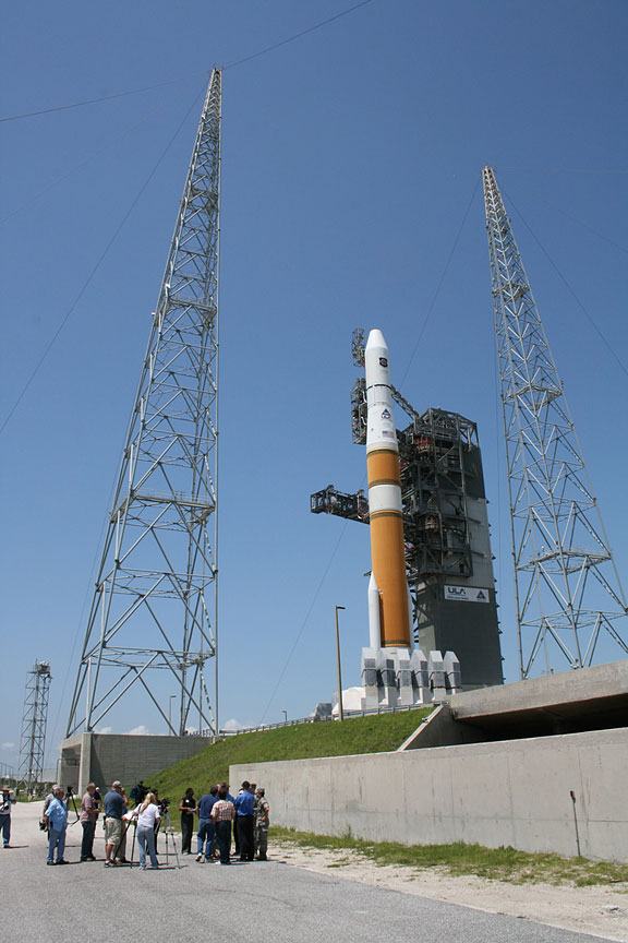
Media visit on May 21 to Delta 4 rocket astride fixed umbilical tower, lightening towers and flame trench. Credit: Ken Kremer
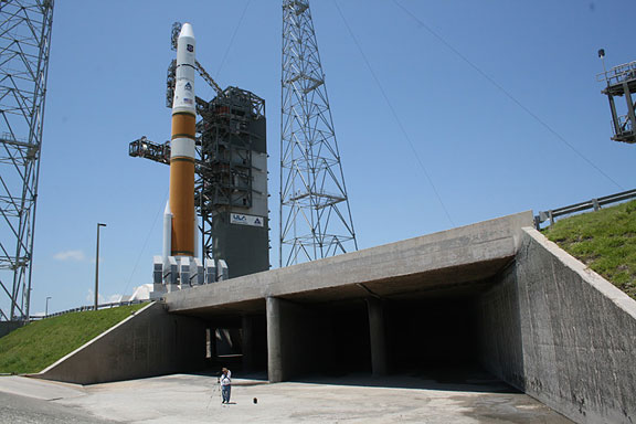
The Delta 4 rocket sits atop flame trench. Nearly a million pounds of thrust will be exhausted through the ducts at liftoff towards photographers location. Credit: Ken Kremer
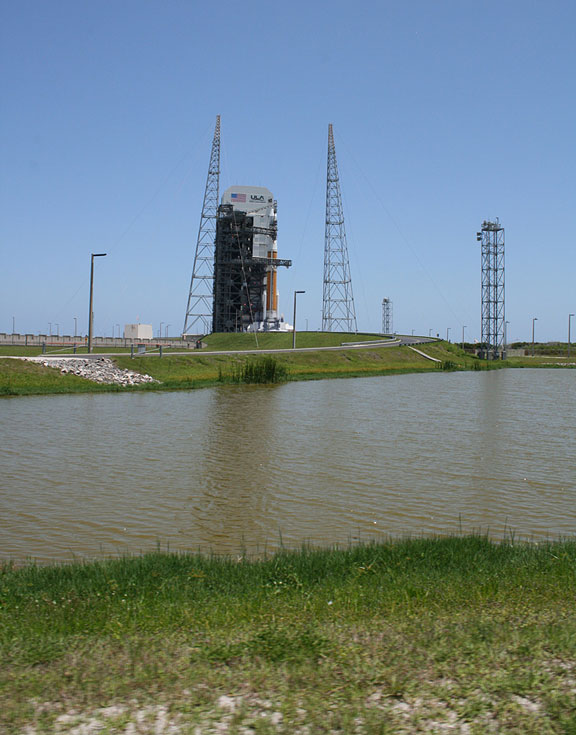
Launch Complex 37 with Delta 4 rocket at Cape Canaveral Air Force Station, Florida. Credit: Ken Kremer
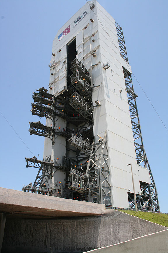
Mobile Service Tower at Complex 37 with swing arms open was retracted from Delta 4 rocket on the morning of May 21, 2010. Gantry sits atop flame trench. Credit: Ken Kremer

Ken Kremer on top of Launch Complex 37 with mighty 212 ft tall Delta 4 rocket which will fly in the Medium+ (4,2) configuration with two 65 ft long solid rocket motors. Credit: Ken Kremer
credit:www.spaceref.com
The launch of a Delta 4 rocket carrying the first in a new series of next generation GPS satellites has been rescheduled for Sunday night (May 23) at 11:17 PM EDT from Cape Canaveral, Florida after the countdown was halted barely 4 minutes prior to liftoff, shortly before midnight on Friday (May 21).
The last minute countdown scrub was called after loss of "the telemetry signal between the GPS and the satellite ground support equipment," according to a statement issued by the Air Force and United Launch Alliance (ULA).
Sunday's launch window runs from 11:17 to 11:35 PM EDT. The weather forecast predicts a 70 percent chance of favorable conditions.
May 2010 marks the 50th anniversary of the Delta program. The first Thor-Delta launched on 13 May 1960.
"This will be the 349th Delta launch. Overall, the Delta family of expendable rockets has a 95.7% success rate. Delta 4 was a 100% success rate since starting 8 years ago," said Bill Cullin, the Delta Launch Director for ULA at Pad 37.
The GPS IIF-1 satellite is the first in an advanced series of 12 satellites funded by the US Air Force which will provide highly accurate, three dimensional position, navigation and timing information on a 24/7 basis in all weather conditions. The spacecraft serve both military and civilian purposes.
The 330 ft tall mobile launch gantry was retracted from around the rocket early Friday morning. Media including myself visited Launch Complex 37 shortly thereafter at noon for a photo op.
See my photo gallery below of the Delta 4 rocket poised at Pad 37.
Watch for my post launch report.
Delta 4 rocket poised to launch on May 23 at 11:17 PM EDT from Space Launch Complex 37 at Cape Canaveral Air Force Station, Florida. Credit: Ken Kremer
Close up of Delta rocket with 4 meter composite payload fairing surrounding GPS IIF-1 navigation satellite. Credit: Ken Kremer
Media visit on May 21 to Delta 4 rocket astride fixed umbilical tower, lightening towers and flame trench. Credit: Ken Kremer
The Delta 4 rocket sits atop flame trench. Nearly a million pounds of thrust will be exhausted through the ducts at liftoff towards photographers location. Credit: Ken Kremer
Launch Complex 37 with Delta 4 rocket at Cape Canaveral Air Force Station, Florida. Credit: Ken Kremer
Mobile Service Tower at Complex 37 with swing arms open was retracted from Delta 4 rocket on the morning of May 21, 2010. Gantry sits atop flame trench. Credit: Ken Kremer
Ken Kremer on top of Launch Complex 37 with mighty 212 ft tall Delta 4 rocket which will fly in the Medium+ (4,2) configuration with two 65 ft long solid rocket motors. Credit: Ken Kremer
credit:www.spaceref.com
Bing versus Google Maps: Voice navigation compared

We tested Bing's voice navigation alongside Google's Android offering.
(Credit: CNET) We took Bing on a few test drives against Google's map navigation, all in the San Francisco Bay Area. Both apps will likely eventually get you where you want to go, but both exhibited overly creative directions and produced their own frustrating errors.
What we liked
We immediately noticed Bing's less tinny-sounding directions bot. Sure, "she" still sounds robotic, but less so than Google's navigatrix. We also appreciated how the Bing app "bings" before sounding off the next direction. The chime was a natural and unintrusive interruption to signal that voice guidance is imminent. It would have been nice if Bing also chimed to indicate that it's time to make a left or right turn, as Magellan's GPS units
What we didn't like
Bing was the more navigationally flawed app in our tests compared with Google's navigation. Google's maps also have more features and options; for example, a street-level and bird's eye perspective of the map.
Within our first two test runs, Bing thrice dispensed misdirections that didn't correlate to the real world, including directing us to circle around a neighborhood even when we were on the same street as the destination address. There were also more trivial directional errors that turned up in subsequent testing.
We should note that commercial GPS navigators also run into the same pitfalls we noticed with Bing's navigation--like offering directions too early or too late and temporarily dropping GPS fixes (specifically within urban canyons)--so we can't dump all our blame on Bing, especially for issues that actually generate from the hardware and environmental access to GPS signal, and not from the software itself.
What else Google does better than Bing
On an absolute basis, we prefer Google Maps navigation to Bing's naviagion for its more faithful directions and more numerous map views, but also for its interface design. It's not exactly a fair fight. Specs-wise, the HTC Incredible
Although Bing has a ways to go to catch up to Google's overall quality, if you've got a Windows phone, the "pro" of free voice navigation outweighs the service's cons. As with similar voice guidance software, Bing fetches directions after you add an address or location, pick a place on a map, select from favorite locations, and choose destinations-by-address book contacts--and it'll automatically reroute if you've missed a turn.
Just take Bing's voice guidance, like all navigation units, with a grain of salt.
Air Force: Tests didn't include troubled GPS unit
DENVER —
The Air Force says it performed no advance testing on the specific type of military GPS receiver that had problems picking up locator signals after a change in ground-control software.
The Air Force said Monday that it performed tests on other equipment, but none of it contained the type of receiver that was unable to lock on to GPS:Global Positioning System satellites after the change.
The manufacturer of the receivers, Trimble Advanced and Military Systems, says it did run advance tests and found no problems.
An Air Force spokesman says its testers didn't have any samples of the affected receiver. He says the Air Force is now acquiring a more representative sample of GPS receivers that are in use.
The problem occurred in January, and the Air Force says it has been fixed.
Credit: The Associated Press
Google confesses it collected Wi-Fi data
SAN FRANCISCO — Google said Friday that for more than three years it has inadvertently collected snippets of private information that people send over unencrypted wireless networks.
The admission, made in an official blog post by Alan Eustace, Google's engineering chief, comes a month after regulators in Europe started asking the search giant questions about Street View, the layer of real-world photographs accessible from Google Maps.
Regulators wanted to know what data Google collects as its camera-laden cars methodically troll through neighborhoods, and what Google does with that data.
Google appears to have acted quickly after the questions were raised. Two weeks ago, Google said it did collect certain kinds of data around the world that identify Wi-Fi networks to help improve its mapping products.
The data on wireless networks can be used for advertising services for mobile phones, which can be pinpointed via a wireless network even if they lack a GPS chip. But the company said it did not collect or store “payload data” — the information being transmitted by users over unprotected networks.
In a confession made Friday that is sure to raise questions about its privacy policies, Google said that its claims were wrong.
Eustace wrote that a review of the Street View software has revealed that due to a programming error in 2006, the company has been mistakenly collecting snippets of data that happened to be transmitted over non-password protected Wi-Fi networks that the
Google camera cars were passing. This occurred in Europe, in the United States and in other major cities elsewhere.
Eustace tried to play down the revelation, saying that Google “never used that data in any Google products.”
Google said it has temporarily halted its Street View cars and will stop collecting Wi-Fi data. Eustace said Google wants to delete the data, in cooperation with regulators, as soon as possible.
But the revelation is likely to set off a firestorm of protest and possibly new legal problems. Google could be accused of intercepting private communications and violating wiretap laws in the United States .
Credit: By BRAD STONE New York Times
Darth Vader Offers His Voice For TomTom GPS Units
Ever wished your GPS gave you more entertaining voice commands while you were driving to your destination? Perhaps that voice could be your favorite character from your favorite movie? VoiceSkins.com -- who brought you celebrity voices from Homer Simpson of The Simpsons and rapper Snoop Dogg -- in partnership with TomTom GPS, Lucas Film and the Rebel Alliance, has released the official Star Wars voices.
The voice of android C-3PO is set to be released in July and Hans Solo's in August. Fans can already download Darth Vader's voice commands on the TomTom Web site for $12.95, while Star Wars-themed start-up screens, sounds and car icons are offered for free.
Below are some outtakes of the recording session with Darth Vader himself:
Darth Vader’s VoiceSkin is the first Star Wars GPS voice to be made available for download by users of TomTom GPS navigation systems.
Users can download Vader's voice for their units at VoiceSkins.com.
credit:
www.ballerstatus.com
Stem cells use GPS to generate proper nerve cells
An unknown function that regulates how stem cells produce different types of cells in different parts of the nervous system has been discovered by Stefan Thor, professor of Developmental Biology, and graduate students Daniel Karlsson and Magnus Baumgardt, at Linköping University in Sweden. The results improve our understanding of how stem cells work, which is crucial for our ability to use stem cells to treat and repair organs. The findings are publishing next week in the online, open-access journal PLoS Biology.
Stem cells are responsible for the creation of all cells in an organism during development. Previous research has shown that stem cells give rise to different types of cells in different parts of the nervous system. This process is partly regulated by the so-called Hox genes, which are active in various parts of the body and work to give each piece its unique regional identity - a kind of GPS system of the body. But how does a stem cell know that it is in a certain region? How does it read the body's "GPS" signals? And how is this information used to control the creation of specific nerve cells?
In order to address these issues, the LiU researchers studied a specific stem cell in the nervous system of the fruit fly. It is present in all segments of the nervous system, but it is only in the thorax, or chest region, that it produces a certain type of nerve cell. To investigate why this cell type is not created in the stomach or head region they manipulated the Hox genes' activity in the fly embryo.
It turned out that the Hox genes in the stomach region stop stem cells from splitting before the specific cells are produced. In contrast, the specific nerve cells are actually produced in the head region, but the Hox genes turn them into another, unknown, type of cell. Hox genes can thus exert their influence both on the genes that control stem cell division behaviour and on the genes that control the type of nerve cells that are created.
"We constantly find new regulating mechanisms, and it is probably more difficult than previously thought to routinely use stem cells in treating diseases and repairing organs, especially in the nervous system", says Thor.
Funding:This work was supported by the Swedish Research Council, by the Swedish Strategic Research Foundation, by the Knut and Alice Wallenberg foundation, by the Swedish Brain Foundation, by the Swedish Cancer Foundation, and by the Swedish Royal Academy of Sciences to ST. The funders had no role in study design, data collection and analysis, decision to publish, or preparation of the manuscript.
Competing interests statement: The authors declare that no competing interests exist.
Citation: Karlsson D, Baumgardt M, Thor S (2010) Segment-Specific Neuronal Subtype Specification by the Integration of Anteroposterior and Temporal Cues. PLoS Biol 8(5): e1000368. doi:10.1371/journal.pbio.1000368
PLEASE ADD THE LINK TO THE PUBLISHED ARTICLE IN ONLINE VERSIONS OF YOUR REPORT: http://biology.plosjournals.org/perlserv/?request=get-document&doi=10.1371/journal.pbio.1000368
PRESS ONLY PREVIEW OF THE ARTICLE: http://www.plos.org/press/plbi-08-05-Thor.pdf
RELATED SYNOPSIS: http://www.plos.org/press/plbi-08-05-ThorSynopsis.pdf
CONTACT
Dr. Stefan Thor
Linkoping University
Dept Clinical Exp Medicine
Linkoping, S-581 85
Sweden
+46-13-22 57 75
stefan.thor@liu.se
Stem cells are responsible for the creation of all cells in an organism during development. Previous research has shown that stem cells give rise to different types of cells in different parts of the nervous system. This process is partly regulated by the so-called Hox genes, which are active in various parts of the body and work to give each piece its unique regional identity - a kind of GPS system of the body. But how does a stem cell know that it is in a certain region? How does it read the body's "GPS" signals? And how is this information used to control the creation of specific nerve cells?
In order to address these issues, the LiU researchers studied a specific stem cell in the nervous system of the fruit fly. It is present in all segments of the nervous system, but it is only in the thorax, or chest region, that it produces a certain type of nerve cell. To investigate why this cell type is not created in the stomach or head region they manipulated the Hox genes' activity in the fly embryo.
It turned out that the Hox genes in the stomach region stop stem cells from splitting before the specific cells are produced. In contrast, the specific nerve cells are actually produced in the head region, but the Hox genes turn them into another, unknown, type of cell. Hox genes can thus exert their influence both on the genes that control stem cell division behaviour and on the genes that control the type of nerve cells that are created.
"We constantly find new regulating mechanisms, and it is probably more difficult than previously thought to routinely use stem cells in treating diseases and repairing organs, especially in the nervous system", says Thor.
Competing interests statement: The authors declare that no competing interests exist.
Citation: Karlsson D, Baumgardt M, Thor S (2010) Segment-Specific Neuronal Subtype Specification by the Integration of Anteroposterior and Temporal Cues. PLoS Biol 8(5): e1000368. doi:10.1371/journal.pbio.1000368
PLEASE ADD THE LINK TO THE PUBLISHED ARTICLE IN ONLINE VERSIONS OF YOUR REPORT: http://biology.plosjournals.org/perlserv/?request=get-document&doi=10.1371/journal.pbio.1000368
PRESS ONLY PREVIEW OF THE ARTICLE: http://www.plos.org/press/plbi-08-05-Thor.pdf
RELATED SYNOPSIS: http://www.plos.org/press/plbi-08-05-ThorSynopsis.pdf
CONTACT
Dr. Stefan Thor
Linkoping University
Dept Clinical Exp Medicine
Linkoping, S-581 85
Sweden
+46-13-22 57 75
stefan.thor@liu.se
iPad 3G uses LCD frame as a giant 3G antenna

For those of you wondering how the iPad manages to lock onto AT&T (NYSE: T)’s wireless data network and GPS satellite signals despite its signal-blocking aluminum unibody casing, iFixIt’s new iPad 3G dissection sheds some light on just how Apple (NSDQ: AAPL) solves the “aluminum problem.” Turns out, the iPad 3G makes the most of its LCD frame by using it as a giant antenna. The black plastic insert near the top of the tablet also allows radio signals to pass through without being blocked by the aluminum shell, but that was already a given. Apple’s use of the LCD frame as an antenna is definitely more interesting.

Aside from the obvious difference of the added 3G radio, the iPad 3G also boasts a GPS receiver. The iPad WiFi model does not have GPS functionality. What’s more, iFixIt’s iPad 3G teardown reveals that the tablet uses a GPS chipset that’s superior to the iPhone 3GS’s GPS hardware. Gone is the 3GS’s Infineon (NYSE: IFX) Hammerhead II GPS chip, replaced by the iPad 3G’s Broadcom (NSDQ: BRCM) BCM4750UBG Single-Chip AGPS Solution. Chalk up a win for the iPad and Broadcom.
What’s most interesting with this teardown is that Apple is employing a fairly novel technique for making the most of the tight space within the iPad’s slim package. The iPad 3G has the same dimensions as its 3G-lacking sibling, but has to pack in more hardware. Rather than making more space for a dedicated radio antenna, Apple is using the LCD frame as a large antenna. Apple also used this technique in the new MacBook Pro, where the frame of the optical drive is used as a WiFi antenna. There’s also a radio antenna underneath the iPad’s black plastic insert.
So, the question is, does the reception from the LCD frame compare well with the iPhone 3G? If you have an iPad 3G and have noticed any differences in reception quality, let us know in the comments below!
More Information
credit: www.intomobile.com
MapQuest iPhone App Revamped To Include GPS Voice Navigation
The MapQuest iPhone App has been given a facelift, and beginning today it now includes GPS voice navigation.
"MapQuest 4 for iPhone" is a free app that brings turn-by-turn navigation by voice to the iPhone. The Android smartphone has long had such capabilities and the iPhone is now officially in the voice GPS navigation game.
It is "basic voice guidance" only, Mashable notes, so while it tells you when to make turns and lets you know if you're off route, it won't pronounce every street name.
But it's a start, and again it is free to download.
MapQuest released its first iPhone App in June 2009 with extremely basic features to compete with the default Google Maps app on the iPhone.
$150K bond for man tracked by GPS in stolen taxi
Bond was set at $150,000 Monday for a man charged with robbery and hijacking after police found him at a Northwest Side gas station by following a stolen taxi cab's GPS signal.
Travis E. Conner III, 18, of the 2900 block of West Fulton Street is charged with one count of robbery and aggravated vehicular hijacking, according to police News Affairs.
Conner was ordered held on $150,000 Monday and a preliminary hearing was set for May 3 in Northwest Felony Court (Br. 50), Cook County State's Attorney's office spokeswoman Tandra Simonton said.
Conner allegedly forced a cab driver out of his taxi at gunpoint about 3:30 a.m. Sunday, the release said. He dropped his cell phone at the scene before fleeing in the cab, which is equipped with a GPS.
Using the GPS, police found the cab at a gas station in the 6300 block of North Central Avenue, the release said. Conner was identified and a semi-automatic handgun was recovered.
credit: www.suntimes.com
BlackBerry Bold 9650 Coming to Sprint
RIM and Sprint on Monday announced the BlackBerry Bold 9650, a follow-up to the popular BlackBerry Tour, which adds Wi-Fi and ditches the troublesome trackball for an optical trackpad.
The Tour's trackball has been users' number-one complaint about the smartphone, because the little ball tends to get gunky or sticky. The Bold 9650 looks almost exactly like the Tour, except RIM has swapped out the ball for a smooth, gunk-free pad. Like the Tour, it has a 2.44-inch, 480-by-360 screen.
The Bold 9650 also includes Wi-Fi, which was missing from the Tour. Like the Tour, the Bold 9650 is a world phone that supports Sprint's 3G CDMA network as well as foreign GSM and HSPA networks. It has GPS, Bluetooth, and a 3.2-megapixel camera, just like its predecessor.
Sprint says the Bold 9650 will be available on May 23 for $199.99 after a $100 mail-in rebate.
Find out more about the Bold 9650 at blackberry.com/bold9650. Previous similar models have also come to Verizon Wireless, but Verizon did not respond to a request for comment.
One Way to Get People Out of Their Cars...
The Dutch have an idea that's good for debate here at home. A proposal would tax the miles driven on a car instead of the current taxes levied on roads and new car purchases.
Specifically, "the plan proposes an average tax of $.07 per mile, with fees higher during rush hour and for commercial vehicles," says Live Earth.
"It would use GPS systems installed in each car to track mileage and automatically bill drivers. The goal, the Dutch government says, is to cut traffic by 15% and reduce transport emissions by 10%."
The Orange County cop charged with hiding GPS in woman's car
WESTMINSTER, Calif.—A Costa Mesa police officer has been charged with hiding a GPS device in a woman's car without her knowledge so he could follow her.
The Orange County district attorney's office says 30-year-old Aaron Parsons was charged Thursday in Westminster Superior Court with a misdemeanor count of unlawfully using an electronic tracking device.
Prosecutors say Parsons hid a GPS device in a 32-year-old woman's car on March 18 so he should show up wherever she was.
After several "chance encounters," the woman became suspicious, checked her car and found the device which belongs to the police department. She reported it to police.
Parsons faces six months in jail if convicted. He is scheduled to be arraigned on Wednesday.
credit:www.mercurynews.com
California considers easing rules on black bear hunting
The population has roughly quadrupled over the last two decades, and some Fish and Game officials say it would remain robust with expanded hunting regions and caps.

A black bear in the foothills above Monrovia. (Rudy Libra)
As outdoor activities in California go, bear hunting is not particularly popular. Officials estimate that, at most, 1% of the state's population hunts black bears. Many of the other 99% are appalled that anyone does.
"I think most people think of it as an anachronism," said state Fish and Game Commissioner Michael Sutton, who speculates that the state's voters may soon ban the practice.
Bear hunting has come a long way since the 1920s, when ranchers and farmers wiped out the grizzly, leaving its sole California presence on the state flag. Gone are the days when you could kill a bear anytime, anywhere, any way.
So Sutton and his fellow commissioners — hunters all — weren't surprised when proposals to expand black bear hunting drew protest.
Nearly 70 environmental, community and animal welfare organizations have lined up against the proposals, most notably the Humane Society of the United States, the American Society for the Prevention of Cruelty to Animals and various chapters of the Sierra Club. In San Luis Obispo County, the board of supervisors passed a resolution last month opposing expansion of hunting into their area.
"We find the totality of the proposal to be unsporting, unfair, inhumane and reckless," said Jennifer Fearing, the Humane Society's Sacramento lobbyist.
But officials at the state Department of Fish and Game say they proposed the changes because California's black bear population is flourishing and spreading.
On Wednesday the commissioners will vote on whether to allow bear hunting in San Luis Obispo County and to increase the hunting area in Lassen and Modoc counties. They'll also decide whether to eliminate a cap on bear kills per season and allow bear hunters to put collars with GPS tracking devices on their hounds.
Black bears long have thrived from Northern California down to Los Angeles and San Bernardino counties, according to Doug Updike, the department's game program manager and a wildlife ecologist. In the last few decades, he said, Fish and Game biologists have seen more bears in San Luis Obispo, Modoc and Lassen Counties. The number of bears statewide, meanwhile, has "increased from under 10,000 in the early '80s to nearly 40,000 now," he said.
"They get hit by cars, we get reports by property owners that they broke into their houses, we get pictures, we know what bear prints look like," he said.
Over the last half-century, California has regulated bear hunting. Trapping has been outlawed and a hunting season set — roughly October to the last Sunday in December, depending on the region. Cubs under 50 pounds and mother bears with their cubs may not be killed. Hunters must obtain identification tags and are allowed one bear per season.
Successful or not, hunters must return their tags to Fish and Game, stating whether or not they bagged a bear. In addition, successful hunters are expected to present their bear skulls to department officials, who extract a tooth from each skull for age monitoring. (Hunters then get the skulls back.) It also is illegal to sell bear parts in California. The state considers possession of as few as two bear gall bladders — lucrative products in Asian markets — evidence of illegal activity.
Still, those who object to the proposed hunting changes say the killing remains too easy.
One proposal they find particularly egregious would allow hunters to equip their dogs with GPS tracking collars that have so-called tip switches, which go off when a dog cocks its head, presumably to look up a tree where it has hounded a bear.
"Given that we are not anti-hunting as much as we are anti-trophy-hunting practices, we zeroed in on these changes," said Fearing of the Humane Society. "Hound hunting is totally unfair and often inhumane — for the bears and the dogs," she said.
Opponents portray hunters as unsportsmanlike folks, watching their GPS devices to see when dogs have treed a bear so they can easily amble over and shoot it. Proponents of the sport, on the other hand, portray hunters with hounds as athletic and focused, sprinting after their dogs, enjoying the chase as much as their canines do. They say that the GPS devices are mostly for tracking lost and injured dogs and that hunters already use radio telemetry to track their dogs.
You don't need a GPS device to tell you when your hounds have found a bear, said Updike, a hunter whose wife has killed a bear. "They can tell by the baying of the hounds how the hounds are doing." He also objected to the idea that California hunters are after trophies, saying that most eat the meat of the bears they kill.
The state relies on a variety of methods to track the bear population. In addition to anecdotal evidence and field work by biologists, hunters' tags tell officials when and where bears were killed.
Critics of changing the hunting rules say monitoring killed bears is not enough to get a sense of their real population. They say the state's methods also don't take into account regional pressures on bear habitats.
The state also monitors the median age of bears killed and the percentage that are female, Updike said, to alert them of when to pull back on hunting. Hunters prefer larger bears, which are usually male. So if a season's total kill is more than 40% female, for instance, "that's a red flag because it means the number of males is getting scarce, which means the hunting pressure is starting to affect the population."
Because of such tracking, he said, state officials are confident that the population is robust enough to withstand well over the 1,700-bear kill figure that now prompts the state to send out an alert closing down the season.
"We looked at a mathematical model for the hunting season which would take 3,100 bears — which we've never ever done," said Updike. "That still is an insignificant number relative to the population. The population would still be robust."
And not having to send out an alert would save thousands of dollars, he said. Some commissioners said they are still not sure how they will vote Wednesday. Commissioner Daniel Richards, who hunts mammals, said he is inclined to widen the hunt. Commissioner Richard Rogers — a duck hunter — said he has no problems with bear hunting but was leaning against the changes.
Sutton, who hunts birds but not mammals, said he too is leaning toward voting no. He's not against bear hunting. But his experience as a former federal game warden has made him sensitive to the dangers of hunting, such as "the potential for increased poaching and illegal commercialization."
"Our wardens are already strapped," he said. "All these things tend to argue against expansion of bear hunting."
carla.hall@latimes.com
credit:www.latimes.com
GPS backpacks identify leaders among flocking pigeons
A freewheeling flock of birds is one of nature’s most endearing spectacles. The flock’s members move with uncanny coordination, changing direction in unison, splitting and reforming, and even landing as one. The intricacies of these synchronized flights are very difficult to entangle. Who is following whom? Is there even a leader and, if so, does the same bird always take up pole position? Our feeble eyes could never hope to discern the answers just by watching a flying flock. But fortunately, we have technology that can do the job for us.
 Máté Nagy from the University of Eötvös, Budapest, has found that flying pigeons obey strict chains of command, even when in flight. He used state-of-the-art GPS devices to track the movements of groups of ten pigeons with exquisite sensitivity. The lightweight monitors, just 16g in weight, captured the subtleties of the pigeons’ twists and turns in mere fractions of a second. Back on the ground, Nagy analysed their recordings to show that pigeons fly according to the pecking orders they establish on the ground. The dominant bird takes the lead and the others follow his directions.
Studying the collective movements of animal groups has been a difficult challenge. Many cameras can be used to film animals moving within the same block of space, but the jostling bodies often block one another from view. Mathematical models can tell us about the basic rules that groups of moving animals adhere to, but they are difficult to test in real life.
But our technology has now become advanced enough to start skirting around these problems. For scientists studying birds, the key breakthrough was the creation of sensors that are light enough to be strapped to a flying bird without compromising its aerial abilities. Now, these sensors include GPS devices that can record a bird’s speed and direction every fifth of a second. Nagy attached such devices to 13 homing pigeons and watched as they flew in flocks of 7 to 11 birds.
 Nagy catalogued every instance when one pigeon changed direction only to be followed by another. By pooling together this data, he created a network of leaders and followers, showing the relationship of each bird to its peers. This colorful diagram shows one such network. Each circle represents an individual pigeon, the arrows point from a leading bird to one that follows it, and the numbers represent the time delay between the leader’s movements and those of its follower’s.
The networks showed that flocking pigeons maintain a dependable hierarchy on the wing. On average, when a leading bird changed direction, its followers would follow suit after around a third of a second. Birds will consistently copy the movements of specific individuals further up the pecking order and, in turn, they are consistently copied by more junior underlings.
What makes a leading pigeon? It seems that skill counts for something. Nagy released each of his birds on a solo flight, some distance from home. When they returned, he found that those who arrived home quickest were also most likely to wield leadership authority, although this link between navigation ability and seniority wasn’t quite statistically significant.
Indeed, the chains of seniority within pigeon flocks are fairly flexible, changing dynamically from flight to flight. Influential birds tend to remain influential but Tamas Vicsek, who led the study, says, “There are days when the pigeon which takes the role most of the time is less active. Perhaps it did not have a good sleep! During these days some of the birds on lower levels of the hierarchy have their chance to lead.”
Nagy’s data also revealed that leaders do indeed take up pole position at the front of the flock. That may seem intuitively obvious to us, but remember that pigeons have a field of vision that extends for almost a full 360 degrees. When you can easily see individuals flying behind you, the leading bird doesn’t necessarily need to be at the front, and yet it does.
More surprisingly, leaders also tend to stay on the left of the flock. Nagy found that the more time that a bird spent behind a leading partner, the more likely it was to be flying on that partner’s right. There’s an obvious reason for this – like us, pigeons have highly asymmetric brains with each half wielding greater influence over certain thought processes. Their right brain, which receives signals from the left eye, controls the ability to recognize other pigeons. So if a pigeon sees one of its peers through its left eye, rather than its right, it responds more quickly or more strongly.

Reference: Nagy, M., Ákos, Z., Biro, D., & Vicsek, T. (2010). Hierarchical group dynamics in pigeon flocks Nature, 464 (7290), 890-893 DOI: 10.1038/nature08891
credit: http://blogs.discovermagazine.com/
Images: by Zsuzsa Ákos
Máté Nagy from the University of Eötvös, Budapest, has found that flying pigeons obey strict chains of command, even when in flight. He used state-of-the-art GPS devices to track the movements of groups of ten pigeons with exquisite sensitivity. The lightweight monitors, just 16g in weight, captured the subtleties of the pigeons’ twists and turns in mere fractions of a second. Back on the ground, Nagy analysed their recordings to show that pigeons fly according to the pecking orders they establish on the ground. The dominant bird takes the lead and the others follow his directions.Studying the collective movements of animal groups has been a difficult challenge. Many cameras can be used to film animals moving within the same block of space, but the jostling bodies often block one another from view. Mathematical models can tell us about the basic rules that groups of moving animals adhere to, but they are difficult to test in real life.
But our technology has now become advanced enough to start skirting around these problems. For scientists studying birds, the key breakthrough was the creation of sensors that are light enough to be strapped to a flying bird without compromising its aerial abilities. Now, these sensors include GPS devices that can record a bird’s speed and direction every fifth of a second. Nagy attached such devices to 13 homing pigeons and watched as they flew in flocks of 7 to 11 birds.
Nagy catalogued every instance when one pigeon changed direction only to be followed by another. By pooling together this data, he created a network of leaders and followers, showing the relationship of each bird to its peers. This colorful diagram shows one such network. Each circle represents an individual pigeon, the arrows point from a leading bird to one that follows it, and the numbers represent the time delay between the leader’s movements and those of its follower’s.The networks showed that flocking pigeons maintain a dependable hierarchy on the wing. On average, when a leading bird changed direction, its followers would follow suit after around a third of a second. Birds will consistently copy the movements of specific individuals further up the pecking order and, in turn, they are consistently copied by more junior underlings.
What makes a leading pigeon? It seems that skill counts for something. Nagy released each of his birds on a solo flight, some distance from home. When they returned, he found that those who arrived home quickest were also most likely to wield leadership authority, although this link between navigation ability and seniority wasn’t quite statistically significant.
Indeed, the chains of seniority within pigeon flocks are fairly flexible, changing dynamically from flight to flight. Influential birds tend to remain influential but Tamas Vicsek, who led the study, says, “There are days when the pigeon which takes the role most of the time is less active. Perhaps it did not have a good sleep! During these days some of the birds on lower levels of the hierarchy have their chance to lead.”
Nagy’s data also revealed that leaders do indeed take up pole position at the front of the flock. That may seem intuitively obvious to us, but remember that pigeons have a field of vision that extends for almost a full 360 degrees. When you can easily see individuals flying behind you, the leading bird doesn’t necessarily need to be at the front, and yet it does.
More surprisingly, leaders also tend to stay on the left of the flock. Nagy found that the more time that a bird spent behind a leading partner, the more likely it was to be flying on that partner’s right. There’s an obvious reason for this – like us, pigeons have highly asymmetric brains with each half wielding greater influence over certain thought processes. Their right brain, which receives signals from the left eye, controls the ability to recognize other pigeons. So if a pigeon sees one of its peers through its left eye, rather than its right, it responds more quickly or more strongly.
Reference: Nagy, M., Ákos, Z., Biro, D., & Vicsek, T. (2010). Hierarchical group dynamics in pigeon flocks Nature, 464 (7290), 890-893 DOI: 10.1038/nature08891
credit: http://blogs.discovermagazine.com/
Images: by Zsuzsa Ákos
iPhone with GPS fingers Double Rock Lexus near laptop-thieves' lair
Technology is always a double-edged sword, full of surprises, particularly for those operating just a few cycles behind the state of the art.
Is it safe to assume that Maifala Tusi, 23 and Jerome J. Satele, 21, both of San Francisco, are familiar with the basic idea of Global Positioning System technology?
Oh, well, perhaps not.
How about the fact that iPhone technology incorporates it?
That’d probably be even less likely.
Or um, oh say, if one were to steal an iPhone and then use it, an exact position of that clever device can be pinpointed by anyone with the right software?
Guess not.
San Francisco District Attorney Kamala D. Harris announced today that both men are being charged with robbery and felony possession of stolen property. She claims they were arrested only hours after they are alleged to have robbed a man and stolen his iPhone and his Apple laptop computer.
The DA says that on April 2, 2010, at 9:55 a.m. a 41-year old man was standing on Van Ness Avenue, at Oak Street, holding his laptop computer, when a man approached him and grabbed his laptop away from him.
The robber then fled down the street with it and the man pursued him until he tackled the perpetrator. As they fought, the man’s iPhone fell out of his pocket and another man grabbed it, then ran into a light-colored Lexus, followed by the robber with the laptop.
They drove westbound on Oak St. in the Lexus and when police arrived later to take a report, the man told them he was able to track his iPhone using its GPS with a tracking application on his computer. He logged onto his computer and pulled up the GPS information, which police then broadcast to SFPD dispatch, which in turn disseminated it to all officers in the field.
The GPS indicated that the man’s iPhone was in the area of Egbert and Hawes streets, adjacent to the Alice Griffith Housing Project in the “Double Rock” area of the Bayview district. Officers found a Lexus parked in the area that was close enough to the description and began surveillance.
About an hour later, several people got into the Lexus and drove away with police following. They pulled it over at 6th Street and Clara Alley.
Authorities said that as the police officers made contact, one of them noticed a passenger, identified as Satele, pass an iPhone to a passenger in the right rear seat of the Lexus, which the officer then seized.
The DA claims the alleged victim was driven to the scene and made a positive identification of both Tusi and Satele as the men who robbed him. He also identified the iPhone and the laptop computer as his property.
The District Attorney said in a press release that Tusi committed the robbery “while on court release in his open felony case. … That case stems from an incident on March 19, 2010, where the defendant is alleged to have committed felony second-degree burglary, grand theft, possession of burglary tools and attempted possession of stolen property. He had been out of custody a total of nine days before he allegedly committed the April 2nd robbery.”
By Thomas Pendergast www.examiner.com
Drunk man steals ambulance
Paul John Sos, 52, was arrested for auto theft, after he stole an ambulance and fled from police.
Sos, led the police on a slow chase Saturday morning, after he took a ambulance that was parked outside Sharp Hospital. Sos was in the hospital for intoxication after he was taken their earlier that morning for being drunk in public. When he checked out of the hospital he saw the ambulance with the keys still in it.
The ambulance had a GPS installed and police tracked the vehicle down at Balboa and Genesee Avenue, but Sos would not pull over. Police followed him for about 12-minutes through Clairemont as he traveled down the city streets at a top speed of 20 mph. Authorities put down spike strips, and after the second attempt they were finally able to stop him.
Sos was booked for suspicion of auto theft, drunk driving and failure to yield to police.
On the way to police headquarters, Sos fell asleep, said San Diego police officer Brad Ruff.
credit:examiner.com
The Magellan RoadMate 1700 isn’t a GPS device for everyone
If you thought the 4.7-inch display on the Magellan RoadMate 1470 was freakishly large, the 1700 one ups the competition with a 7-inch display. That's ridiculous. It's almost like having two iPhones connected to one another for one gorgeous display. Of course, the features are all there, but we're mesmerized with the stunning display at a $239 price tag.
CNET writes, "The Magellan RoadMate's OneTouch menu puts the most commonly accessed destinations and searches at your fingertips at all times. The smartly designed destination confirmation screen gives you a good deal of flexibility as to how they get where they're going. Its large 7-inch touch screen gives you more real estate for maps and menus."
However, "In urban environments, the 1700 takes longer to establish satellite lock and can be inaccurate. Its 7-inch screen size may be too much for smaller dashboards and can make mounting it awkward. Its battery life is extremely short."
In conclusion, "The Magellan RoadMate 1700 isn't a GPS device for everyone, but with its huge screen and road-trip-friendly features, we think truckers and RV drivers will love it."
HTC HD2 commercials surface, show off the multimedia-monster in all its glory
#start
The T-Mobile HTC HD2 has a huge display, and it knows how to use it. What? You haven't heard of the HD2? Well, that's just fine, because HTC has released a pair of HD2 commercials that should get your blood flowing for multimedia monster of a Windows Mobile phone. The ads showcase the HD2's "ridiculously big screen," which, of course, stretches the measuring tape to 4.3-inches in the diagonal. Unfortunately, we aren't really shown anything else about the handset – we figure the powers that be at HTC wanted to simply convey how awesome the display is for watching movies and TV shows.
So, what are these commercials missing? Well, there's no mention of the bundled Blockbuster app that lets you download movies to your HD2 over the air. We didn't see anything about the HD2's 1Ghz Snapdragon processor, 5-megapixel camera, 3G data, WiFi, GPS, mciroSD card slot, 3.5mm headphone jack or the camera's touch-focus feature. If they had mentioned all the things that make the HTC HD2 the single most impressive Windows Mobile smartphone to ever come to market, we'd be looking down the barrel of a multi-minute ad.
Good thing for you we have plenty of HD2 coverage to drool over. Check out our hands-on overview of the HD2.
If you're thinking about picking up an HD2, you might want to order one through T-Mobile (NYSE: DT)'s website right quick. You never know when they're going to sell out again.
MapQuest 4 for iPhone now offers free voice-guided GPS navigation!

Google Maps Navigation already offers it, as does Nokia (NYSE: NOK)’s Ovi Maps, and now MapQuest is getting into the free turn-by-turn, voice-guided GPS navigation game. MapQuest has announced that its MapQuest 4 for iPhone app has been updated to give users voice-guided turn-by-turn navigation service for absolutely free! The app will track your iPhone via GPS and alert you when you approach an exit, turn, or other navigation directions. It’ll even reroute you at the push of a button when you miss an offramp.
Google (NSDQ: GOOG) provides free GPS nav service on Android OS-powered phones, which gives Android phones a strong appeal among tech-conscious types on a budget. Nokia also offers free sat-nav through its clunky Ovi Maps for those of you still using Symbian-based phones. Now, the iPhone can lay claim to having a free voice-guided GPS solution of its own.
If you have an iPhone 3G or 3GS running iPhone OS 3.x, you can download MapQuest 4 for free from the iTunes AppStore. Seeing as how it’s free and offers services that you normally have to pay through the nose for, we’d say it’s totally worth the few clicks it’s going to take you to download the app.
credit:http://www.intomobile.com By Will Park
Police Blotter: GPS used to fight speeding ticket
Police Blotter: GPS used to fight speeding ticket
An Ohio man is trying to beat a speeding ticket through an unusual defense: claiming that his cell phone's GPS records show he was driving under the speed limit.
Jason Barnes received two points on his license and a $35 fine for allegedly driving 84 mph in a 65 mph portion of Interstate 75 in March 2009. But he says that his employer uses GPS tracking on his Verizon Wireless phone to detect speed limit violations--and those logs prove he wasn't speeding.
So far, Barnes hasn't had much luck. An Ohio appeals court ruled last Monday that there was not enough evidence about how Verizon Wireless GPS alerts worked to toss out the speeding ticket.
"We find that the credible evidence clearly supports the trial court's judgment that Barnes was traveling in excess of 65 miles per hour on Interstate 75," Judge Stephen Shaw wrote on behalf of the three-judge panel. "We cannot find that the trial court, acting as the factfinder in this case, clearly lost its way and created such a manifest miscarriage of justice that the conviction must be reversed."
The panel gave more weight to the prosecution's evidence, which included police in an Ohio State Highway Patrol airplane saying they calculated how fast Barnes was driving (no radar gun was used). Barnes claims the logs showed he was traveling at 50 mph, saying the relatively slow speed was because of heavy truck traffic on I-75 at the time.
"Barnes presented no evidence from a person with personal knowledge regarding how the GPS calculates speed, whether there is any type of calibration of the equipment used to detect speed, whether the methods employed by his particular company to detect speed are scientifically reliable, or the accuracy of the GPS' speed detection," the panel said.
It's possible, in other words, that the case could have turned out differently if Barnes had hired an attorney and taken additional steps to demonstrate how Verizon Wireless' GPS tracking worked.
That's happened before. In 2007, an Australian man successfully used GPS data downloaded from his car to show that he was traveling at or below the speed limit. The speeding ticket was eventually thrown out, as was one in England.
credit:http://news.cnet.com/8301-13578_3-20001248-38.html
Argyle Style for GPS with Team Garmin(R) versions of Edge(R) 500 and nuvi(R)
OLATHE, Kan., Mar 16, 2010 (BUSINESS WIRE) -- Garmin International Inc., a unit of Garmin Ltd. /quotes/comstock/15*!grmn/quotes/nls/grmn (GRMN 35.59, -0.32, -0.89%) , the global leader in satellite navigation, today announced new limited-edition color schemes for the aerodynamic Edge 500 and nuvi navigation devices, unveiling argyle designs inspired by the iconic orange and blue patterns of professional cycling's Team Garmin-Transitions. The argyle Edge 500 and a new neutral Edge 500 in black and white will be launched at the Tour of California, included in unique team promotions and also made available at participating local cycling specialty retailers. The argyle nuvi models will be sold exclusively at Tour of California, May 16-23.
"Fashion, function and fun intertwine with these argyle designs, perfect for a lighthearted road trip or a hardcore road race," said Dan Bartel, Garmin's vice president of worldwide sales. "Team Garmin has used Edge technology to win professional races around the world, and these new models help us spread the spirit of the Argyle Armada to even more handlebars and dashboards."
 Budget-friendly and weighing a mere 2 ounces, Edge 500 features a high-sensitivity GPS receiver, requires no calibration and can be switched quickly between bicycles. It also connects wirelessly with ANT+(TM) compatible third-party power meters. Edge 500 tracks speed, distance, time, GPS position, elevation, calories burned, climb and descent. All of this data can be displayed, shared and analyzed on maps and charts at Garmin Connect(SM). For extra-precise climb and descent data, Edge 500 uses a barometric altimeter to pinpoint changes in elevation. And thanks to a recent software update, available as a free download at www.garmin.com, owners of any Edge 500 can now design workouts with multiple steps based on time, distance, calories, power output or heart rate. This feature also allows them to establish workout targets based on speed, calories, cadence, power output and heart rate.
The sleek and slim Edge 500 combines more data than ever into one device. In addition to syncing with compatible power meters, Edge 500 also pairs wirelessly with Garmin speed/cadence sensors and features advanced heart rate-based calorie computation when used with a Garmin heart rate monitor. Edge 500 also displays temperature readings, changes time zones automatically and alerts riders if they're moving but the timer is not running. With up to 18 hours of battery life, Edge 500 features a low-profile, quarter-turn mount that fits easily on the stem or handlebars. The new argyle Edge 500 is packaged with Garmin's premium soft-strap heart rate monitor, speed/cadence sensor, bike mount, AC charger and USB cable. The neutral Edge 500 comes with the bike mount, AC charger and USB cable, and it can be paired with the other optional accessories when purchased separately to best suit each specific cyclist's needs.
Thanks to Garmin's Edge products, recreational cyclists have been able to use the same technology employed on the Pro Tour. Now two new promotions help them get a step closer to feeling like they're in the peloton. Throughout the month of April, Slipstream Sports and Felt Bicycles are giving subscribers to Garmin's fitness email newsletters a chance to buy a team replica Felt F1 -- the same model that Team Garmin's pros ride. This bike is built by team mechanics and comes packaged with an argyle Edge 500, full team kit and team casual apparel and is only available while supplies last. Team Garmin fans also can go the extra mile with their argyle at the Tour of California, where this new Edge 500 will be bundled with a replica Team Garmin jersey from Pearl Izumi. For details about these and other exclusive packages and promotions, visit www.garmin.com/teamgarmin and www.slipstreamsports.com.
Also in limited availability at Tour of California, nuvi will get an argyle makeover. Featuring either a 3.5" or 4.3" touchscreen, the argyle nuvi 1200 and argyle nuvi 1300 showcase the familiar intuitive interface, turn-by-turn directions with spoken street names, and the expansive database of more than six million preloaded points of interest, such as restaurants, hotels, gas stations and coffee shops. Travel is made easy through nuvi's ecoRoute fuel-efficient navigation, enhanced pedestrian options and ultra-thin design for unmatched portability.
Cyclists and fans can track Team Garmin's featured rides -- or download, analyze and share activities of their own - by participating in Garmin Connect, an online community of more than 20 million activities around the world. Garmin Connect displays metrics such as time, distance, speed, elevation and heart rate. This information is shown through charts, illustrations, reports and a variety of map representations including street, photo, topographic, and elevation maps as well as the popular Google Earth application. Garmin Connect users can search for activities in their area and try the activities for themselves by uploading the data to Garmin devices.
Edge 500 is the latest breakthrough from Garmin, which has spent more than 20 years developing technologies and innovations to enhance users' lives, making Garmin a household name in the automotive, aviation, marine, wireless, outdoor and fitness industries. For more about features and availability, as well as information about Garmin's other products and services, go to www.garmin.com, www.garmin.blogs.com and http://twitter.com/jakesjournal.
About Garmin International Inc.
Garmin International Inc. is a subsidiary of Garmin Ltd. /quotes/comstock/15*!grmn/quotes/nls/grmn (GRMN 35.59, -0.32, -0.89%) , the global leader in satellite navigation. Since 1989, this group of companies has designed, manufactured, marketed and sold navigation, communication and information devices and applications -- most of which are enabled by GPS technology. Garmin's products serve automotive, mobile, wireless, outdoor recreation, marine, aviation, and OEM applications. Garmin Ltd. is incorporated in the Cayman Islands, and its principal subsidiaries are located in the United States, Taiwan and the United Kingdom. For more information, visit Garmin's virtual pressroom at www.garmin.com/pressroom or contact the Media Relations department at 913-397-8200. Garmin, nuvi and Edge are registered trademarks, ANT and ANT+ are trademarks and Garmin Connect is a service mark of Garmin Ltd. or its subsidiaries.
About Slipstream Sports
Founded in 2005, Slipstream Sports LLC is a highly progressive sports management company dedicated solely to promoting the ethical growth of American cycling.
About Team Garmin-Transitions
Team Garmin-Transitions is dedicated to promoting ethical sporting and developing the next generation of cycling champions. Team Garmin-Transitions competes in a full schedule of professional cycling races in the U.S. and Europe. Additional information is available at www.slipstreamsports.com.
Notice on forward-looking statements:
This release includes forward-looking statements regarding Garmin Ltd. and its business. All statements regarding the company's future product introductions are forward-looking statements. Such statements are based on management's current expectations. The forward-looking events and circumstances discussed in this release may not occur and actual results could differ materially as a result of known and unknown risk factors and uncertainties affecting Garmin, including, but not limited to, the risk factors listed in the Annual Report on Form 10-K for the year ended December 26, 2009, filed by Garmin with the Securities and Exchange Commission (Commission file number 0-31983). A copy of Garmin's Form 10-K can be downloaded at www.garmin.com/aboutGarmin/invRelations/finReports.html. No forward-looking statement can be guaranteed. Forward-looking statements speak only as of the date on which they are made and Garmin undertakes no obligation to publicly update or revise any forward-looking statement, whether as a result of new information, future events, or otherwise.
Photos/Multimedia Gallery Available: http://www.businesswire.com/cgi-bin/mmg.cgi?eid=6215044&lang=en
SOURCE: Garmin International Inc.
"Fashion, function and fun intertwine with these argyle designs, perfect for a lighthearted road trip or a hardcore road race," said Dan Bartel, Garmin's vice president of worldwide sales. "Team Garmin has used Edge technology to win professional races around the world, and these new models help us spread the spirit of the Argyle Armada to even more handlebars and dashboards."
The sleek and slim Edge 500 combines more data than ever into one device. In addition to syncing with compatible power meters, Edge 500 also pairs wirelessly with Garmin speed/cadence sensors and features advanced heart rate-based calorie computation when used with a Garmin heart rate monitor. Edge 500 also displays temperature readings, changes time zones automatically and alerts riders if they're moving but the timer is not running. With up to 18 hours of battery life, Edge 500 features a low-profile, quarter-turn mount that fits easily on the stem or handlebars. The new argyle Edge 500 is packaged with Garmin's premium soft-strap heart rate monitor, speed/cadence sensor, bike mount, AC charger and USB cable. The neutral Edge 500 comes with the bike mount, AC charger and USB cable, and it can be paired with the other optional accessories when purchased separately to best suit each specific cyclist's needs.
Thanks to Garmin's Edge products, recreational cyclists have been able to use the same technology employed on the Pro Tour. Now two new promotions help them get a step closer to feeling like they're in the peloton. Throughout the month of April, Slipstream Sports and Felt Bicycles are giving subscribers to Garmin's fitness email newsletters a chance to buy a team replica Felt F1 -- the same model that Team Garmin's pros ride. This bike is built by team mechanics and comes packaged with an argyle Edge 500, full team kit and team casual apparel and is only available while supplies last. Team Garmin fans also can go the extra mile with their argyle at the Tour of California, where this new Edge 500 will be bundled with a replica Team Garmin jersey from Pearl Izumi. For details about these and other exclusive packages and promotions, visit www.garmin.com/teamgarmin and www.slipstreamsports.com.
Also in limited availability at Tour of California, nuvi will get an argyle makeover. Featuring either a 3.5" or 4.3" touchscreen, the argyle nuvi 1200 and argyle nuvi 1300 showcase the familiar intuitive interface, turn-by-turn directions with spoken street names, and the expansive database of more than six million preloaded points of interest, such as restaurants, hotels, gas stations and coffee shops. Travel is made easy through nuvi's ecoRoute fuel-efficient navigation, enhanced pedestrian options and ultra-thin design for unmatched portability.
Cyclists and fans can track Team Garmin's featured rides -- or download, analyze and share activities of their own - by participating in Garmin Connect, an online community of more than 20 million activities around the world. Garmin Connect displays metrics such as time, distance, speed, elevation and heart rate. This information is shown through charts, illustrations, reports and a variety of map representations including street, photo, topographic, and elevation maps as well as the popular Google Earth application. Garmin Connect users can search for activities in their area and try the activities for themselves by uploading the data to Garmin devices.
Edge 500 is the latest breakthrough from Garmin, which has spent more than 20 years developing technologies and innovations to enhance users' lives, making Garmin a household name in the automotive, aviation, marine, wireless, outdoor and fitness industries. For more about features and availability, as well as information about Garmin's other products and services, go to www.garmin.com, www.garmin.blogs.com and http://twitter.com/jakesjournal.
About Garmin International Inc.
Garmin International Inc. is a subsidiary of Garmin Ltd. /quotes/comstock/15*!grmn/quotes/nls/grmn (GRMN 35.59, -0.32, -0.89%) , the global leader in satellite navigation. Since 1989, this group of companies has designed, manufactured, marketed and sold navigation, communication and information devices and applications -- most of which are enabled by GPS technology. Garmin's products serve automotive, mobile, wireless, outdoor recreation, marine, aviation, and OEM applications. Garmin Ltd. is incorporated in the Cayman Islands, and its principal subsidiaries are located in the United States, Taiwan and the United Kingdom. For more information, visit Garmin's virtual pressroom at www.garmin.com/pressroom or contact the Media Relations department at 913-397-8200. Garmin, nuvi and Edge are registered trademarks, ANT and ANT+ are trademarks and Garmin Connect is a service mark of Garmin Ltd. or its subsidiaries.
About Slipstream Sports
Founded in 2005, Slipstream Sports LLC is a highly progressive sports management company dedicated solely to promoting the ethical growth of American cycling.
About Team Garmin-Transitions
Team Garmin-Transitions is dedicated to promoting ethical sporting and developing the next generation of cycling champions. Team Garmin-Transitions competes in a full schedule of professional cycling races in the U.S. and Europe. Additional information is available at www.slipstreamsports.com.
Notice on forward-looking statements:
This release includes forward-looking statements regarding Garmin Ltd. and its business. All statements regarding the company's future product introductions are forward-looking statements. Such statements are based on management's current expectations. The forward-looking events and circumstances discussed in this release may not occur and actual results could differ materially as a result of known and unknown risk factors and uncertainties affecting Garmin, including, but not limited to, the risk factors listed in the Annual Report on Form 10-K for the year ended December 26, 2009, filed by Garmin with the Securities and Exchange Commission (Commission file number 0-31983). A copy of Garmin's Form 10-K can be downloaded at www.garmin.com/aboutGarmin/invRelations/finReports.html. No forward-looking statement can be guaranteed. Forward-looking statements speak only as of the date on which they are made and Garmin undertakes no obligation to publicly update or revise any forward-looking statement, whether as a result of new information, future events, or otherwise.
Photos/Multimedia Gallery Available: http://www.businesswire.com/cgi-bin/mmg.cgi?eid=6215044&lang=en
SOURCE: Garmin International Inc.
NYC Grabs Cabbies' GPS Data, Busts Open $8M Taxi Scam
In New York City, a cab driver can be your best friend, regaling you
with tales about the Big Apple of yore, and blasting Boston for an epic
sing-along. He or she can also be your worst enemy by innocently
proclaiming the credit card machine is "broken" after the ride has
ended, forcing you to trek to an ATM, and thus allowing him to get off
tax-free. Apparently, however, the truly seedy side of New York cabbies
has been revealed by GPS, and amounts to a scam of nearly $8.3 million.
Apparently, drivers have been flipping the switch that denotes the
type of ride a passengers is taking in order to fraudulently change
the $0.40 city rate to the $0.80 charged to passengers traveling in
Westchester and Nassau counties. After one rider complained, a
commission was established, and began collecting GPS data from cabs in
order to review trip locations and rates throughout the city. The
commission's findings? A whopping 1.8 million improper fares charged
throughout the city, or the biggest fraud in taxi history.
Now, before you get your collective commuter panties in a bunch, there
is a little bit of a silver lining here. The commission had to sort
through 360 million trips to get its data, meaning the overall fraud
numbers are a paltry percentage. In total, 36,000 drivers activated the
lucrative rate change at least once, but they weren't necessarily all
purposefully deceitful. As cabbie Rana Singh told the New York Times,
"You're driving, your fingers are small, the buttons are tiny."
Bhairavi Desai, executive director of the New York Taxi Workers
Alliance, also told the times that she believes it's a "systematic
failure on the part of the meters and technology." That's perhaps true,
for those among the 36,000 that messed up once or twice. However, the
commission discovered that over 3,000 drivers implemented the hike more
than 100 times. One driver was found doing it to 574 passengers in just a single month.
Agency officials are reportedly ordering cab manufacturers to create a
notification system for when the rate goes into effect. In the meantime, just like anything in New York City,
two lessons can be learned here: a couple bad apples can ruin it for the rest of us; and always know how
much something costs (and, then, what you are actually paying
for it). [From: New York Times]
GPS Study: Walmart Top US Destination; Md. Drivers Use It Most Read more: http://www.sfgate.com/cgi-bin/article.cgi?f=/g/a/2010/03/10/urnidgns852573C400693880002576E300016DB5.DTL#ixzz0hqmWNuVX
New Global Positioning System (GPS) data released today by GPS-navigation provider TeleNav offers a number of insights into the behaviors--and preferences--of U.S. drivers.
The data, collected randomly from millions of U.S. TeleNav users throughout 2009, suggests American drivers are most frequently searching for big-box retailers like Walmart and Target, as well as a quick caffeine fix via Starbucks. And on a state-level, residents of Maryland are by far the most frequent users of GPS for navigation.
TeleNav customers employ the service via mobile applications for popular smartphones like Apple's iPhone and Research In Motion's (RIM) BlackBerry, as well as via standalone GPS navigation units, like TeleNav's Shotgun.
The top "states" for GPS-based navigation in 2009 were Maryland, Washington, D.C., Massachusetts, North Carolina and California, according to TeleNav. In fact, Maryland residents used TeleNav for twice as many trips per month than the national average, according to the company.
TeleNav says its users conduct millions of GPS-based searches a month. The leading U.S. city-areas for GPS-searches were Los Angeles, Dallas/Forth Worth, Chicago, Houston and Atlanta.
And Americans are using TeleNav frequently to help find popular retailers; the most sought-after U.S. businesses in 2009 were Walmart, Starbucks, Target, Best Buy and Bank of America.
Additional noteworthy data includes the most frequently searched for types of food--Pizza in Chicago and Chinese in New York; along with the cities in which drivers most often used GPS to avoid traffic and locate the cheapest fuel--Los Angeles and Phoenix, respectively.
For additional information on TeleNav and its 2009 national GPS usage data, visit the company's website.
And if you're a BlackBerry smartphone user, check out my tips, tricks and best practices for getting the most out of TeleNav for BlackBerry.
Copyright (c) 2010, IDG News Service. All rights reserved. IDG News Service is a trademark of International Data Group, Inc.
Read more: http://www.sfgate.com/cgi-bin/article.cgi?f=/g/a/2010/03/10/urnidgns852573C400693880002576E300016DB5.DTL#ixzz0hqmKzIvC
Petraeus Expects Iraqi Leaders to Remain Inclusive
By Gerry J. Gilmore
American Forces Press Service
WASHINGTON, March 7, 2010 – Despite sectarian and ethnic differences across Iraq’s political landscape, Army Gen. David H. Petraeus said he expects new Iraqi leaders will continue their previous government’s efforts to employ inclusive coalitions to bridge those divides.
Today marks the second democratic, parliamentary elections held in Iraq since the fall of the late dictator Saddam Hussein in 2003, Petraeus, commander of U.S. Central Command, told CNN’s GPS television news program host Fareed Zakaria.
Petraeus said he would like to see the new Iraqi government be as inclusive as the previous one. That is to say, he said, the new government would continue “to be generally representative of the people, responsive to all the people, and to continue the progress that has been achieved over the course of the last couple of years, again, in the economic, social and political realms.”
The way forward in Iraq, Petraeus said, depends on continued accommodations between Sunnis, Shias, Kurds and other members of Iraq’s diverse sectarian and ethnic population. Iraq’s population is majority Shia Muslim.
“All progress that has been made [in Iraq] to date -– all of the legislation that’s been passed and so forth -- has all required cross-sectarian, cross-ethnic coalitions,” Petraeus said.
Petraeus also expects continued employment of such coalitions in the running of the Iraqi government.
“Because, when you do the math, there’s no way that a prime minister will be elected without a cross-sectarian, and indeed, cross-ethnic coalition developing to elect that individual” and other key legislators.
In a statement released by the White House today, President Barack Obama congratulated Iraqis “for casting their ballots in this important parliamentary election”
Obama praised Iraqis “who refused to be deterred by acts of violence” and exercised their right to vote. Iraqi security forces are responsible for maintaining security for today’s election. There have been reports of some deaths due to insurgent actions.
“We mourn the tragic loss of life today,” Obama continued, “and honor the courage and resilience of the Iraqi people who once again defied threats to advance their democracy.”
Meanwhile, Petraeus told Zakaria, there are now about 96,000 U.S. troops in Iraq. That number, the general said, is expected to decrease to about 50,000 U.S. forces by the end of August.
“And, of course, with the new government in place, there will be the dialogue” between the U.S. and Iraqi governments on future security agreements.
Other topics Petraeus discussed with Zakaria included Iran, Afghanistan, Pakistan and the issue of homosexual service within the U.S. military.
Regarding alleged Iranian aspirations to obtain nuclear weapons, Petraeus said he’s not sure whether the Iranian leadership has yet made the decision to actually develop such devices.
However, the general said, it’s important to realize Iran has been working to acquire “all of the components of a program to produce nuclear weapons” and the means to deliver them.
Many Middle East nations, including Israel, Petraeus said, look at alleged Iranian efforts to acquire nuclear arms as a “worrisome” development. That’s why, he said, the United States and its allies are considering employing stricter sanctions against Iran if it doesn’t come clean about its nuclear aspirations.
Turning to Afghanistan, Petraeus said counterinsurgency operations in Marja have gone well.
“This is a clear, hold and build, or re-build, depending on the damage done, and transition,” Petraeus said of the Afghan-coalition operations in Marja that began Feb. 13.
In order to be successful, he said, the Marja operation has to be seen by the Afghan people as a means of bettering their lives.
Afghanistan President Hamid Karzai has been fully involved in details of the Marja operation, Petraeus said. Karzai, he added, also “has rightly” called into question what occurred when Afghan civilians have inadvertently become casualties of war.
Turning from Afghanistan to Pakistan, Petraeus pointed to the Pakistani government’s realization that internal extremists are directly threatening its existence. Pakistani military forces have been engaging extremists operation in the country’s Swat Valley region.
“That has been a very impressive counterinsurgency operation,” Petraeus said of Pakistani military forces’ gains made against insurgents in Swat Valley.
Pakistan’s leaders, Petraeus said, are realizing the truth of Defense Secretary Robert M. Gates’ assertion that Taliban, al-Qaida and other extremists operating in the Afghanistan-Pakistan region share a symbiotic relationship and belong to a syndicate of terrorism that threatens all law-abiding nations.
Zakaria asked Petraeus about his stance regarding the possible repeal of the 1993 “Don’t Ask, Don’t Tell” law by Congress regarding homosexuals serving in the U.S. military. Defense Secretary Gates has directed a 10-month review to determine the potential impacts across the military if the law is repealed.
Petraeus observed that he’d once served with some CIA officers of both genders who’d been reputed to be homosexual. The general implied that the two CIA officers’ reputed sexual preference didn’t seem to negatively impact their work performance or professionalism.
Petraeus said he’s slated to appear before Congress soon to provide his views about homosexuals serving in the military.
“You, know, I think this is something that can be worked through, frankly,” Petraeus told Zakaria. Other nations’ militaries that allow homosexual men and women to openly serve, he noted, employ “very sensible and pragmatic policies.”
credit:www.defense.gov
Your GPS cellphone makes a Star Trek communicator look like a kid's toy
By Scott Edmonds, THE CANADIAN PRESS
WINNIPEG - So, you've got GPS on your smartphone and can tackle the trip to Uncle Charlie's new house in the suburbs with a fresh sense of confidence.
But are you ready for a trip down the Amazon?
"Interesting, I'd love to do that test," laughs Christ Peralta, head of social location services for Nokia.
"That's a real interesting use case. I wouldn't advise it," says a slightly more definitive Ken Kershner, vice-president of software at Research in Motion's subsidiary Dash.
OK, it was just a thought. And perhaps smartphone GPS isn't ready for the jungles of Brazil, but both men suggest it's perfectly designed for the more urban jungle most cellphone users must deal with every day.
GPS stands for Global Positioning System. It's a worldwide navigation tool, supplied courtesy of the U.S. military, that relies on 24 satellites that transmit their location and the current time.
Signals arrive at GPS receivers at slightly different times based on how far away each satellite is from the receiver. With at least four satellite signals, a receiver can then calculate its position. Hand-held GPS receivers are usually accurate to within 10 to 20 metres.
It's old hat now and in use for commercial navigation, helps hunters find their way in the woods and leads fishermen unerringly back to that hotspot they found last year. It continues to grow in popularity as the cost of receivers comes down.
Cellphones have had GPS locators in them since 2005 because the United States decided it wanted to be able to track cellphone location for emergency purposes after Sept. 11, 2001.
While initially the feature just sat there, cellphone manufacturers were quick to make good use of the application. Besides finding out where you are, or where you're going, you can also keep track of your children, post your location to Facebook or find a lost phone.
Manufacturers are always on the lookout for new ways for customers to use their cellphones and there seem to be few limits on the applications. Smartphones already make the old 'communicator' that once seemed so slick on "Star Trek" look like a kid's toy.
"I think the key is to find out what consumers want," says Peralta. "The second step is to make it easy out of the box."
He says that's what Nokia is trying to do with its latest offering for its smartphones: the preloaded Ovi mapping system that makes them into more effective GPS units.
Onboard maps in a GPS-enabled smartphone mean it can function as an independent GPS unit, without connection to a cellphone network.
That's a key feature for anyone who wants to use their GPS-enabled phone while travelling and doesn't want to incur hefty roaming or long-distance charges.
"It can be a travel companion when you travel abroad . . . or can help you rediscover your city," says Peralta. "There are features that require online connections. . . but the consumer has the choice."
All of the new Ovi-loaded Nokia GPS smartphones can function without connection to a cellular network, he says.
Just how popular is the GPS feature in cellphones? A recent Angus Reid survey for Nokia found that 38 per cent of Canadians use some form of GPS device, but most use a traditional portable unit. So far, only eight per cent use it on their cellphone.
But that's already twice as many as use an installed in-car device. The survey of 1,000 people is considered accurate to within plus or minus 3.1 per cent, 19 times out of 20.
There have been suggestions that cellphone GPS might someday replace stand-alone devices. Kershner says it can replace the stand-alone units, "in some uses."
"It depends how much value you place on GPS." And, he adds, how much you're willing to pay. Cellphones are pretty near the bottom of the price point, considering what else they offer.
But function is also important and all GPS devices have their requirements and capabilities. The most expensive can cost thousands of dollars and are also the most accurate, using other aids to further refine position to within a metre in some cases.
But what if you want to use your GPS-equipped smartphone in your car, for example.
First, there are power requirements that have to be met. Turning on the GPS chip in a phone means it uses power faster. So if it's being used in a car, it needs to be able to connect to the car's power supply.
If it's used in a car it also has to have a large enough screen to be seen easily or have a good text-to-voice feature, so you can hear the instructions to get to your destination (these are what's generally known as a 'turn-by-turn' GPS guidance system). And be sure to check for d
ap-l
BC-20100303-US-FEA-Food-Tiny-Wine-Bottles, Budget
code:8
Budget
Eds:TastingRoom as one word is cct.
See Photos
CP Lifestyle, Beverage, Retail, Food
Vintners hope tiny tasting bottles will pay big dividends in wine marketing
By Michelle Locke
THE ASSOCIATED PRESS
NAPA, Calif. - Thousands of people visit the Domaine Carneros Winery each year, snapping pictures in front of the 18th-century-style chateau and sipping wine on the terrace overlooking a sweep of green vineyards.
Now, the winery hopes to extend the experience with new sample-sized bottle kits that aim to send the tasting room experience home - you read the tasting notes, you sip, you rekindle those sensory memories. All without ponying up for a full bottle of untried wine - or stripping down for an airport security check.
"You can stay in Iowa or New York or Miami, wherever you are, and you can have this experience come to you," says Eileen Crane, CEO and founding winemaker of Domaine Carneros.
The idea seems simple enough. You try sample sizes of drapes, mouthwash and wallpaper. Why not wine?
But test-driving wine isn't as simple as opening a big bottle and pouring it into a bunch of little ones, says Tim Bucher, CEO and founder of TastingRoom Inc., which launched last year and is making the 50-millilitre samples for Domaine Carneros.
For one thing, wine is sensitive to oxygen. So if a little bit is exposed to a lot of oxygen, which is what would happen if you merely poured wine through a funnel, that will change the character of the wine. Beyond that, each winery has its own method of bottling, such as "sparging," in which bottles are filled with an inert gas before filling to ensure the right conditions.
Bucher's process involves a patent-pending technology called Total Anaerobic Sample Transfer Environment - TASTE - that aims to replicate what the winery does on a miniature scale. Transfers are conducted in a sealed, zero-oxygen chamber, similar to a semiconductor "clean room," and the goal is to come up with something that duplicates the tasting room experience.
"For us it was never about taking wine from a barrel and just putting it into a smaller vessel. That would not capture the real product that wineries are selling," Bucher says.
While it's hard to say for certain this hasn't been done, sample-size wine bottles appear to be new, says Robert Smiley, director of wine industry programs in the Graduate School of Management at the University of California, Davis. It's too early to say whether the kits will be successful, but they sound like a good idea, he says. "I'm all for innovation."
For Bucher, the power of try-and-buy wine grew out of his experiences at his own winery. Going over the books, he realized, "Wow, my tasting rooms are gold. I asked myself how could I scale my tasting rooms intergalactically."
Another player in the small-is-big trend is San Francisco-based Crushpad, the do-it-yourself winery where individuals can select fruit and supervise the making of small batches of wine to get the vintner experience without the farming headaches (and sizable capital investment).
Crushpad's "Tiny Bottles," also 50 millilitre, use an oxygen-free transfer system and are being used in conjunction with Brixr, a web-based tasting service.
At Domaine Carneros, the kits will be available in the Napa Valley tasting room - price about $25 - and also will be offered to wine club members as a convenient, low-cost way to try wines. Domaine Carneros is primarily known for its sparkling wines, so the six-bottle kits are being used to showcase its lesser-known still wines.
"We think it's a wonderful way for people to reconnect with the winery," says Crane.
-
TastingRoom: http://tastingroom.com/
Domaine Carneros: http://www.domainecarneros.com
Crushpad: http://www.crushpadwine.com/
Brixr: http://www.brixr.com
credit:technology.canoe.ca
Subscribe to:
Posts (Atom)


