
I have a TomTom GO 920t there are a few things that bother me. I have a 920t /currently running Navcore 8.01 and the newest north american maps.
My Background:
I work for an alphabet agency. I spend countless hours on surveillance and travelling to arrest badguys and take their contraband. I can say for the most part the 920 is great. However their are a few things that cause me concern and will prompt me to sell the TT and get a Garmin.
The 920 has all the Bells and whistles. I love the map share feature but the biggest problem I see right now is that TT is running off Tele Atlas. Tele Atlas maps are not as accurate as Navteq. I hear a lot of people saying their are limitations to both providers but I can tell you that in my experience that is not true. Tele Atlas is not as good on the West Coast.
It has been my experience that Navteq and Tele Atlas bring back similar results in established neighborhoods but in new places Tele Atlas has some problems. The address/block information is off. So if you search for an address that is not well established you could be 1/2 mile away from where you need to be.
Which is why the TT POI database is filled with errors. I just got the new maps and attempted to put in new POI's "By address." Doing so places the POI about 1/2 mile away from the actual location. I conducted a search of POI's in the Database and learned that 7/10 poi's in that area were off by almost a 1/2 mile. (The POI's appeared to be in the middle of the dessert). It's not the device. It's Tele Atlas. Was easy to figure out. I used Yahoo maps (Navteq) and Google Maps (Tele Atlas) to search for the same address. They were off by almost 1/2 a mile.
Don't believe me try it yourself (758 S Watson rd, Buckeye, Arizona) type it in your TT or google you get sent to rattlesnake land. Type it in Yahoo maps / Garmin you get the right location.
I'm not bashing the TT. The device is great. The tele atlas maps the TT's are based on are off at least where I was trying to put these POI's in.
I will say this, the new maps and IQ routing makes a big difference on routing. Understand that I have a government issued Garmin Nuvii 205 that I compare the routes to on a daily basis. With IQ routing the TT's routes in my local area are very close to the routes I would drive on a daily basis. The Nuvii 205 routes are not as good as the TT with IQ but are better than the TT's without IQ. (I know quality of routes are subjective. This is just my opinion based on about 90-100 routes travelled).
So here is my summary. If TT finds the address. My experience has been that it will get you there using the best route. Again this is compared to a Nuvii 205 without traffic and without any advanced routing like what is found on the high end Nuvii's. I have always found the address using TT (100 or so trys) with one exception. I was searching for an address for a search warrant and put in the correct city and address. Unfortunately according to Tele Atlas I was not in the city of Goodyear I was in Buckeye. Well I didn't know that and I had no idea which city to search for because I'm not from that area. Caused me to have to get to the location with the assistance of another agent. Shoudn't ever have that problem when I have a GPS not a deal breaker though I just have to realize the limitations of the search engine. Didn't have the Garmin then so I couldn't compare.
The POI database is where the Garmin 205 is leaps and bounds ahead of the TT. I'm not certain how many POI's the 205 has preloaded. I can say this though I have never been driving in circles looking for a meet location since I picked up the Garmin it has always been spot on.
Two weeks ago a got the auto restart bug. Couldn't use the GPS until I came home and reloaded the OS, Maps and flashed the device. All is well now but I would have been PO'd if I needed to get to a meet or travelled out of town while it was bugging out like that.
Again I'm not down on the TT I'm just aware that there are some limitations. The mapshare function is absolutely awesome. There are a lot of things that make the TT a great device. I just think in a year or so when it's time to get a new device I'm going to test the waters with a high end Garmin.
And if this thing start bugging again Ebay and a new Garmin sooner than later. I can't afford to have an unreliable device.
Just my .02

HowTo: Add Itinerary Planning to TomTom ONE 3rd Edition
Here are instructions on how to restore the TomTom ONE 1st Edition main menu on the TomTom ONE 3rd Edition, allowing access to Itinerary Planning (which was something I really was disappointed TomTom chose to skip on the 3rd Edition). A lot of us got the ONE 3rd on Black Friday ($130) and were disappointed by how stripped down it was. While you can't get back SD and BlueTooth support, you can easily get back Itinerary Planning.
NOTE: THESE INSTRUCTIONS WILL ONLY WORK WITH TOMTOM 7.x. DO NOT UPGRADE TO 8.x OR ANY OTHER VERSION BEFORE OR AFTER APPLYING THIS MODIFICATION! If you do (like I did), your TomTom will freeze when turning on and will completely lock up and reboot when you try accessing Itinerary Planning. See the bottom of this post for details on how to un-break it if you accidentally upgrade. The fix is relatively simple.
Please remember that while this is not a hack (TomTom actually explains how to perform menu and POI customization in their SDK documentation) and it does not void your warranty, you should still proceed at your own risk, since we are transferring files to the TomTom unit. Never unplug your TomTom while files are transferring. And always remember to make backups. So now that's out of the way, let's start:
1) Open WordPad, NotePad, or some other simple text editor of your choice and copy and paste the following block of text (this restores the TomTom ONE 1st Edition menu). You can customize this menu and add and sort your own tasks however you like. See http://opentom.org/Menu_structure for details.
MENUBLOCK|BLOCK_MAIN|BTM_DONE|
MENUPAGE|TASK_PAGE1|Main Menu 1 of 2|
MENUITEM|TASK_NAVIGATE_TO|
MENUITEM|TASK_MENU_FIND_ALTERNATIVES|
MENUITEM|TASK_DELETE_ROUTE|
MENUITEM|TASK_ADD_FAVORITE|
MENUITEM|TASK_MENU_PREFERENCES|
MENUITEM|TASK_PAGE2|
MENUPAGE|TASK_PAGE2|Main Menu 2 of 2|
MENUITEM|TASK_MENU_PLAN_ATOB|
MENUITEM|TASK_SHOW_MAP|
MENUITEM|TASK_MENU_ROUTE_INSTRUCTIONS|
MENUITEM|TASK_SHOW_ROUTE_DEMO|
MENUITEM|TASK_ITINERARY|
MENUITEM|TASK_PAGE1|
2) Save the file as TomTom.mnu (case sensitive). Make sure no additional extensions are added to the file name! You don't want TomTom.mnu.rtf or TomTom.mnu.txt. By default, Windows does not show extensions of known file types, so it's easy to make a mistake here.
3) Plug in your TomTom ONE 3rd to your computer via the included USB cable, turn it on, and tap Yes, when it asks you if you want to connect to your computer, and then (through your computer) create a new folder in the root directory of your TomTom called SDKRegistry (case sensitive).
4) Upload the file TomTom.mnu to SDKRegistry. Once the upload is complete, unplug the USB cable after safely preparing the TomTom (either through HOME, click Device > Disconnect Device, or through Windows, right click on Safely Remove Hardware icon and click Safely Remove Hardware). Itinerary Planning should be in the same location (page 2) on the Main Menu as it was on the TomTom ONE 1st Edition.
These instructions will disallow access to a few features on the 3rd that you may want (don't worry, it's easily reversible). So you might want to tweak this menu a bit depending on what you use. Tweaking menus will not remove any features (like MapShare), it simply changes the menus and doesn't let you access the features not included in the menu. And it's not a hack. It's a customization, so it won't void your warranty.
Here's a few pics showing my TomTom ONE 3rd Edition with Itinerary Planning working:


-How to undo this-
Just plug in your TomTom and delete the SDKRegistry directory.
-How to customize menu more easily-
Visit http://www.skux.net/tomtom/menubuilder2/index.php, select your language flag on the top (default is German), and then follow the instructions on that page to customize the menu. You can also download a program that's very similar to this site at http://www.gregoryduncan.com/ttmd/index.php.
-How to custimize the menu manually-
OpenTom.org has a list of menus available for the Go (most are compatible with ONE as well) on their wiki at http://opentom.org/Menu_structure
-I accidentally upgraded to version 8.x and now my TomTom freezes when I try to access Itinerary Planning-
This was annoying, but thanks to forum member tendawolf, it's a simple fix:
1) Go to your My Documents folder and navigate to TomTom\HOME\Download\Program\ and delete the version 8 folder. If you don't have the version 7.x folder there, you can download it at
http://www.savefile.com/files/1677339 or http://www.minihost.org/kubel/TomTom_Application_for_ONE_3RD_Edition.zip
2) Make sure you perform a backup just in case something goes wrong. If you aren't worried, you will at least want to back up MapSettings.cfg from the map folder, as this will be overwritten and you will lose all your favorites when you go back to 7.x. Once you finish all these steps, you will want to re-upload your MapSettings.cfg back to the map folder on your TomTom. (Thanks dhn).
3) Plug your TomTom into your computer via the USB cable, turn it on, and tap "Connect" when it prompts you to connect to your computer.
4) Open TomTom Home if it doesn't automatically start. DO NOT INSTALL ANY UPDATES. Instead, click "Back".
5) Go to "Add Maps, Traffic, Voices, etc..." on the TomTom Home main menu.
6) Click the More arrow (about 3 times) and go to "Items on my computer".
7) Click the + sign next to Applications. "TomTom Application for ONE 3RD Edition" should show up. Click on "More info..." to verify that the version number is 7.x (7.116 if you downloaded the version from these instructions). If it is correct, click the "Add" button.
8) Let it finish and follow the instructions on the screen. (It should tell you to unplug your TomTom, let it restart, plug it back in, and click "Connect"). Once the blinking accessing icon disappears the the "do-not-unplug" picture disappears, it should be safe to unplug and give it a test. Several things will be reset, including the following: Language, home location, colors, voice, history (including recent POIs, auto-fill, and city buoyancy where it places most often used cities toward the top), favorites, keyboard, and probably a few other preferences and settings.
9) If you backed up any files, now would be a good time to restore them. Please note that some files that were compatible with v8.x may not be with v7.x.
10) Last, but not least, do not update "TomTom Application" ever again! You can install other updates, though.
credit:gpsreview.net
An Inexpensive External GPS Antenna (Part 2)
Following previous article
An Inexpensive External GPS Antenna (Part 1)
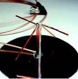
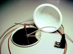
Final Assembly
I’ve found that an empty, upturned 8-ounce cream cheese container makes a practical radome for the antenna. More importantly, it helps protect the internalworkings from mechanical damage.
I usually don’t paint the container but I do remove the silk-screened label by using an automotive rubbing compound. It takes some effort but it does come off. Just follow the manufacturer’s instructions. Be careful not to apply too much pressure to the lid when you rub the label off. It’s made of a different plastic than the container and stretches easily.
You should be able to snap the base plate into the lid of the container. It’s a tight fit so just work your way around the lid until the entire base plate is flush with the lid bottom You might have to cut a notch in the lip of the lid to allow the coax to exit the unit cleanly. Carefully align the coax with the lid notch and snap the cover onto the lid. It’s normal for the top of the transmission line assembly to slightly raise the “bump” on the container bottom.
Theory of Operation
In a normal turnstile, we would have a double dipole configuration with both dipoles on the same plane but rotated 90° from each other. Additionally, the second dipole is fed 90° out of phase with an other ¼ wavelength of coaxial cable. This creates some difficult assembly problems since you would have to isolate the second dipole section from ground while maintaining the tight distance and spacing requirements. Due to the size constraints, this second dipole connection would require a very small diameter coax that might be difficult to work with and even harder to obtain. With this antenna, we cheat a bit and use a selfphased quadrature type feed.
To obtain circular polarization without a coaxial phasing line, the shorter dipole is cut so its impedance is 50 – j50 Ω. The longer dipole is fashioned into an inverted V shape and cut so its impedance is lowered to 50 + j50 Ω. With the combined asymmetrical dipoles and with them spaced slightly closer than ¼ wavelength to the ground plane, the antenna’s impedance is near 50 Ω with a much more omnidirectional pattern, an important consideration for reception of GPS satellites close to the horizon.
You should see an improvement over the supplied stock antenna. You can tweak the antenna by bending the wires up and down gently and watching the results on your GPS unit. Be careful of the solder joint—it’s rather fragile. Adjust for maximum displayed signal. Repositioning the
antenna may also improve reception. With this antenna, I routinely receive five to eight satellites on my Garmin II receiver. If you are using a GPS unit that sends dc voltage volts up the coax to power an external preamp or amplified antenna, don’t worry. Since the elements are not grounded or shorted, there is no dc path. Just be careful not to let either end of the active elements touch ground.
[Be advised that some GPS receivers with internal patch antennas have an antenna switching circuit. This circuit disables the internal antenna when an amplified external antenna is attached. The receiver senses current flow that is intended to power the amplifier of the external antenna.
If your receiver has this feature, you will want the switch to activate and disable the internal patch antenna. Placing
1 kΩ to 5 kΩ across the ground and center conductor of the coax should be sufficient. Check with the manufacturer of your GPS receiver.—Ed.]
If you are mobile, most GPS receivers will do a fair job of receiving signals through the windshield of a car. During the
summer, however (and especially out here in the Southwest), the GPS gets baked while sitting in the hot sun.
Obviously, one way to solve this problem is to locate the receiver somewhere cooler and place this external antenna on the dash. Once that’s done, you’ve protected your expensive receiver while sacrificing a $10 antenna.
This design was not intended for outside use, hence the lack of external mounting suggestions. Any prolonged exposure to the elements will degrade the antenna’s unprotected metal parts. My suggestion—if you plan on using this unit outside, at least spray the metal parts with clear lacquer and seal the exposed coax end with RTV. Otherwise, don’t waste a lot of time weatherproofing it. Because these antennas are so cheap and easy to build, if one does deteriorate throw it away and build another. Perhaps you might want to keep a couple of spares on hand, just in case.
An Inexpensive External GPS Antenna (Part 1)
Final Assembly
I’ve found that an empty, upturned 8-ounce cream cheese container makes a practical radome for the antenna. More importantly, it helps protect the internalworkings from mechanical damage.
I usually don’t paint the container but I do remove the silk-screened label by using an automotive rubbing compound. It takes some effort but it does come off. Just follow the manufacturer’s instructions. Be careful not to apply too much pressure to the lid when you rub the label off. It’s made of a different plastic than the container and stretches easily.
You should be able to snap the base plate into the lid of the container. It’s a tight fit so just work your way around the lid until the entire base plate is flush with the lid bottom You might have to cut a notch in the lip of the lid to allow the coax to exit the unit cleanly. Carefully align the coax with the lid notch and snap the cover onto the lid. It’s normal for the top of the transmission line assembly to slightly raise the “bump” on the container bottom.
Theory of Operation
In a normal turnstile, we would have a double dipole configuration with both dipoles on the same plane but rotated 90° from each other. Additionally, the second dipole is fed 90° out of phase with an other ¼ wavelength of coaxial cable. This creates some difficult assembly problems since you would have to isolate the second dipole section from ground while maintaining the tight distance and spacing requirements. Due to the size constraints, this second dipole connection would require a very small diameter coax that might be difficult to work with and even harder to obtain. With this antenna, we cheat a bit and use a selfphased quadrature type feed.
To obtain circular polarization without a coaxial phasing line, the shorter dipole is cut so its impedance is 50 – j50 Ω. The longer dipole is fashioned into an inverted V shape and cut so its impedance is lowered to 50 + j50 Ω. With the combined asymmetrical dipoles and with them spaced slightly closer than ¼ wavelength to the ground plane, the antenna’s impedance is near 50 Ω with a much more omnidirectional pattern, an important consideration for reception of GPS satellites close to the horizon.
Operation
Connect the antenna to the GPS receiver and watch the signal-strength indicator.You should see an improvement over the supplied stock antenna. You can tweak the antenna by bending the wires up and down gently and watching the results on your GPS unit. Be careful of the solder joint—it’s rather fragile. Adjust for maximum displayed signal. Repositioning the


antenna may also improve reception. With this antenna, I routinely receive five to eight satellites on my Garmin II receiver. If you are using a GPS unit that sends dc voltage volts up the coax to power an external preamp or amplified antenna, don’t worry. Since the elements are not grounded or shorted, there is no dc path. Just be careful not to let either end of the active elements touch ground.
[Be advised that some GPS receivers with internal patch antennas have an antenna switching circuit. This circuit disables the internal antenna when an amplified external antenna is attached. The receiver senses current flow that is intended to power the amplifier of the external antenna.
If your receiver has this feature, you will want the switch to activate and disable the internal patch antenna. Placing
1 kΩ to 5 kΩ across the ground and center conductor of the coax should be sufficient. Check with the manufacturer of your GPS receiver.—Ed.]
If you are mobile, most GPS receivers will do a fair job of receiving signals through the windshield of a car. During the
summer, however (and especially out here in the Southwest), the GPS gets baked while sitting in the hot sun.
Obviously, one way to solve this problem is to locate the receiver somewhere cooler and place this external antenna on the dash. Once that’s done, you’ve protected your expensive receiver while sacrificing a $10 antenna.
This design was not intended for outside use, hence the lack of external mounting suggestions. Any prolonged exposure to the elements will degrade the antenna’s unprotected metal parts. My suggestion—if you plan on using this unit outside, at least spray the metal parts with clear lacquer and seal the exposed coax end with RTV. Otherwise, don’t waste a lot of time weatherproofing it. Because these antennas are so cheap and easy to build, if one does deteriorate throw it away and build another. Perhaps you might want to keep a couple of spares on hand, just in case.
Tips for New GPS Navigation Users
Tips for New GPS Navigation Users
BY JONATHAN MELBY
You'll probably be a little anxious to get going when you first open the box and take out your GPS system. Here are a few tips that will help you get off to a good start.

Get a baseball cap
A GPS left sitting on the dash can be an attractive target for thieves. You can reduce the chance that yours will be stolen by keeping it hidden. One easy way to do this is to cover it with a baseball cap.
Help your GPS find satellites
A GPS receiver needs a little time to find satellites before it can calculate your initial location. This is harder to do when you're driving around (especially if you're changing directions or passing near large obstructions).
You can shorten the startup process by waiting in your driveway (or other open area) until satellite signals are acquired. Most models have a screen that shows the GPS signal status.
Mark a few waypoints
After your GPS has found its initial location, you should set waypoints for your home and a few other key locations. Familiar waypoints shown on the map make it easier to stay oriented as you're driving around.
Check your speedometer

Speedometers in many vehicles are inaccurate. If your speedometer and GPS don't agree, your GPS is probably closest to the truth.
Note: Speeds reported by GPS usually lag by a second or two, so you need to stay at a steady speed to get an accurate reading.
Ask people if they're in a new part of town
Newer subdivisions and office parks are often missing from GPS maps. If a destination is not in your GPS, let it take you to a nearby cross street and get directions from there. After you arrive at the destination, set a waypoint if you expect you might need to find it again in the future.
Make driving your top priority
GPS is fun to use, but be safe. Enough said.
Don't be bullied by your GPS
Your GPS may calculate routes that take you through areas you'd rather skip. Take the road(s) you want and let the GPS recalculate using your road instead.
If your GPS is stubborn and refuses the hint, most systems will let you setup "custom avoid" preferences to skip specific roads or areas. You can do this sometime when you find free time in a parking lot.

Watch the satellites screen
After the novelty of looking at maps of familiar areas has faded, you should spend some time watching the satellite status screen.
Although it's not especially productive, you can learn how sensitive your navigation system is to nearby obstructions that block GPS signals.
credit:roadmapgps.com
Having Fun with GPS
Having Fun with GPS
Almost everyone has heard of the Global-Positioning System by now, and many radio hobbyists own a handheld GPS receiver. For the uninitiated, the GPS system works with a network of 24 satellites orbiting some 12,500 miles up in the sky. Each one has an atomic clock to set the precise timing that is part of the math used by a land-based a GPS receiver to triangulate its location on the face of the earth. GPS satellites continuously transmit signals and data. Those signals are picked up by GPS receivers, with up to 12 satellites being received simultaneously. A calculator in the GPS receiver crunches the data, and shows it to us as latitude and longitude.
The GPS term for a set of latitude and longitude coordinates is waypoint. If you connect the waypoint dots, you have what’s called a route. As you move with a GPS in your hand, it generates a virtual breadcrumb trail called a track. Waypoints, routes and tracks can be saved in a GPS memory. Now you have the basic GPS vocabulary.
Got a Map in Your Hand?
When people want to know how much to spend on a GPS receiver, we ask if they want to see a map in their hand. Entry-level GPS receivers display basic geographic information: latitude, longitude, elevation, direction, and bearing.
They calculate the distance between points and estimate your arrival time. They will also have a screen that shows a graphic representation of the points you marked with the GPS, as if you had drawn a sketch, but that isn’t a scale map. For that, you have to spend more, and most GPS users think it’s worth the expense. Better quality GPS receivers come with a base map of North America, but with such a large area to cover, the maps don’t include much detail. Spend a little more, and you get map memory, up to 24mb, to upload more maps and a higher level of detail: city maps, topographic maps, and “points of interest” such as hotels restaurants, museums, and so on. Garmin and Magellan, perhaps the most popular makers of handheld GPS units, produce software for this purpose.
Although you will see maps on your PC screen during the process of uploading them to your GPS, they aren’t meant to compete with real desktop mapping software.
By Anton Ninno, N2RUD, and Jim Kuhl, N2STK
How to update map data on GPS device?
How to update map data on GPS device?
You can update online here: http://www8.garmin.com/unlock/update.jsp (you must enter the serial number). Or you can buy from amazon (search for Garmin map updates). It comes in DVD-ROM which you download through your computer to the GPS via a USB cable (should be provided with the GPS).
But since you just bought the GPS, I think it should have come with 2008 maps, and there should be no need to update. Depending on the area where you live or travel, roads usually don't change quickly enough to justify updating more often than once every two years or longer.
How to Update Your Magellan Maestro GPS

How to Update Your Magellan Maestro GPS
- Visit Magellan’s homepage (www.magellangps.com). Click Products and select Maps & Software from the drop-down menu. You’ll see selections for Outdoors and Recreational Maps and Street Maps.
- To obtain new Outdoors and Recreational Maps, first insert an SD Card into your device, then connect a USB cable from your notebook to the device and download the maps you desire for $29.99 to $99.99.
- To obtain new Street Maps, click the name of your model and you’ll be taken to a page where you can purchase the DVD for $79.99.
- Once you receive the Street Maps DVD, install it onto your notebook. Connect your unit via USB and download the new maps.
Nokia turn mobile phones into traffic probes
(PhysOrg.com) -- Drivers in the San Francisco Bay Area with GPS-enabled mobile phones can soon tap into new technology that promises to transform traffic monitoring. Moments before midnight on Monday, Nov. 10, researchers from the University of California, Berkeley, and Nokia Research Center, Palo Alto will publicly release pilot software that turns cellular devices into mobile traffic probes providing real-time information on traffic flow and travel times.
As part of this Mobile Millennium project, anyone can download the free software at http://www.traffic.berkeley.edu. It will work on most GPS-enabled cell phones operating on GSM networks - such as AT&T and T-mobile - that are capable of installing and running Java applications. The Web site will be continually updated with a list of specific Nokia and non-Nokia phone models compatible with the software. Because of the large amount of data transmitted by the system, researchers recommend that participants have an unlimited data plan.
As vehicles pass through the system's virtual trip lines - geographic markers defined by GPS coordinates - the phones will send anonymous speed and location readings to servers. The data will be integrated into traffic models that produce an estimate of traffic flow, then relayed back to the mobile phones and posted online at traffic.berkeley.edu.
The software is being developed as part of the Mobile Millennium project by researchers from UC Berkeley's College of Engineering, Nokia Research Center, Palo Alto and UC Berkeley's California Center for Innovative Transportation. The new system uses digital mapping data from Chicago-based NAVTEQ, recently acquired by Nokia.
Heading the research teams are Alexandre Bayen, UC Berkeley assistant professor of systems engineering in the Department of Civil and Environmental Engineering, and Quinn Jacobson, research leader at Nokia Research Center.
"As we have entered the era of the mobile Internet, cellular devices are providing us with ubiquitous sensing capabilities that will rapidly revolutionize location-based services," said Bayen. "In particular, traffic information systems will be enriched by combining mobile sensor data with static sensor data. The Berkeley research focuses on developing the novel algorithms needed to integrate this data into traffic models and make the information meaningful to the public."
The researchers said the system could eventually spread to include any area with mobile Internet connections, including secondary side streets and rural roads not currently monitored by traffic sensors.
"The proliferation of GPS-enabled devices globally has driven tremendous growth in location-based experiences," said Henry Tirri, senior vice president of Nokia Research Center. "Mobile Millennium, with its unique collaboration of private and public stakeholders, has been designed to demonstrate that everyday people can help address global problems such as traffic congestion. Nokia is proud to be part of this research."
Mobile Millennium is supported by the U.S. Department of Transportation through the federal SafeTrip-21 initiative, which seeks technology solutions to improve safety and reduce congestion on the roadways, as well as by the California Department of Transportation (Caltrans).
"This technology has the potential to provide better quality coverage over more area than has ever been monitored before, allowing motorists to make better traveling decisions," said Randell Iwasaki, Caltrans chief deputy director. "More importantly for state transportation officials, the increased coverage will provide a substantial set of information which will be used to proactively manage the transportation network."
The release of the pilot software comes nine months after researchers put the new technology to its first major road test, dubbed Mobile Century, using Nokia's N95 GPS-enabled mobile devices placed in 100 cars. The pilot software to be publicly released Monday night is partially based upon the prototype version tested during that field experiment.
From the beginning of the project, researchers built privacy safeguards into the system so no data that can be tied to a particular phone will be created, transmitted or stored. This "Privacy by Design" system strips the traffic data from individual device identifiers, uses banking-grade encryption techniques to protect the transmission of data and draws data only from targeted roadways where traffic information is needed.
Nokia's Tirri also emphasized that users ultimately control the service and can turn off the system's ability to transmit traffic data at any time.
The first phase of the Mobile Millennium system launch will include traffic data for highways, which includes major commuter corridors within and between the San Francisco Bay Area and Sacramento. As more users come online, the researchers expect to have sufficient data to produce information on some arterial routes in the Bay Area and Sacramento.
During the first month of the pilot, software downloads will be limited to manage capacity. Additional information about supported GPS-enabled mobile phones will be posted. By April 2009, the researchers expect to reach the estimated pilot system capacity of 10,000 users.
"With this pilot, the San Francisco Bay Area becomes the starting point for the growth of a new cyberinfrastructure system based upon data provided by users," said Bayen. "Eventually, anyone in the country will be able to download the free software to transmit and receive traffic data and participate in the creation of a new traffic information system for their city or community."
"It's been gratifying to have such large public and private entities working together to move this valuable service through its research phases so it can get out to the public," said CCIT Director Thomas West. "The best part about this pilot is that that everyday people can participate, and the more people who use it, the better it will work."
This collaboration between UC Berkeley and the Nokia Research Center was supported by a seed grant from UC Berkeley's Center for Information Technology Research in the Interest of Society (CITRIS)
credit:physorg.com
How to Update Your Garmin nüvi GPS

How to Update Your Garmin nüvi GPS
- Point your browser toward Garmin’s update page (www8.garmin.com/unlock/update.jsp), and enter your product’s serial number.
- If your device has new maps available, the site will direct you to a page where you can order an update DVD for $70.
- When you receive the DVD, pop it into your computer (Mac or PC), and connect the nüvi via a USB cable.
- The DVD will prompt you to enter a product key, which is on the back of the DVD’s jewel case. The software will automatically launch and begin updating the device.
Control room set up to monitor GPS-enabled patrol vehicles
CHENNAI: The state government has set up a modern control room at the state traffic planning
cell (STPC) office on Kamarajar Salai to monitor the 122 GPS-enabled police patrol vehicles deployed along the national highways across the state.
“The new system will help the police patrol vehicles to reach the accident spot within two minutes of the incident. The movement of patrol vehicles will be monitored round the clock from the STPC office. Our main aim is to reduce the deaths due to road accidents,” state transport minister KN Nehru told The Times Of India. He was talking to mediapersons after attending a review meeting to gauge the effectiveness of its initiatives to reduce the number of accidents in the state.
He said the road safety policy of the government had laid out broad principles along with programmes for traffic improvement. A state level monitoring committee will be formed to implement the policy. To instill greater seriousness, deterrent penal action has been introduced for traffic-related offences. First offence results in suspension of driving licence and any subsequent offence would result in cancellation of licence, minister said.
“We have introduced a new system called MARS (monitoring and response system), which will work through a GPS-GIS system fitted on the highway police patrol vehicles. Incidents of robbery and road accidents can be monitored through the central monitoring unit and immediately send the patrol cars for help.STPC can be contacted at 2844 4444. MARS will also study the accident prone areas in the state and take necessary steps to reduce road accidents,” KN Nehru said.
credit:timesofindia.indiatimes.com
How to Update Your TomTom GPS

How to Update Your TomTom GPS
- Install the TomTom Home software onto your notebook from the device’s bundled updates DVD.
- Plug in your unit via USB.
- Click Preferences, and then Check for Update.
- If a message appears stating that you have the latest maps, you’re done.
- If a message appears stating that there are new maps available, click the Download button to sync them to your unit free of charge.
Fujitsu Unveils Mini-Tablet PC With GPS Navigation
The LifeBook U820 includes Garmin Mobile PC navigation software, a global positioning system that provides turn-by-turn, voice-prompted street directions.

Fujitsu on Tuesday introduced a mini-tablet PC with built-in personal navigation, and a desktop-replacement notebook that includes a small touch-screen display for keeping more information visible without cluttering the main desktop.
The LifeBook U820 includes Garmin Mobile PC navigation software, a global positioning system that provides turn-by-turn, voice-prompted street directions. The system offers mobile professionals, particularly in sales and in field services, an alternative to carrying a separate GPS device.
The tablet, which is powered by an Intel Centrino Atom Z-series processor, has a 5.6-inch touch-screen display, a QWERTY keyboard and a zoom utility for easier viewing. The system weighs 1.32 pounds and offers 7.5 hours of battery life on a four-cell battery and 3.5 hours on a 2-cell battery.
In addition, buyers have the option of up to a 120 GB hard disk drive or up to a 64 GB solid-state drive. The system comes with Windows Vista and a 1.3 mega-pixel Web cam and includes a fingerprint sensor for security and integrated Wi-Fi and Bluetooth wireless support. In the first quarter of next year, the U820 will be available with optional 3G network support from wireless carriers. Prices start at $1,049 The LifeBook N7010 desktop-replacement notebook includes a four-inch touch-screen display, which can be used for photo slide shows, CD/DVD controls and application shortcuts. The system, which has a 16-inch main display, is powered by a dual-core, 2.26 GHz Intel Core 2 Duo P8400 processor. Other features include a Blu-ray disc player, 4 GB of system memory, and an ATI Radeon HD 3470 graphics processor with 256 MB of GDDR3 memory. In addition, the notebook has integrated Wi-Fi and Bluetooth wireless technology, a 1.3 megapixel Webcam and a Memory Stick/SD card slot. Prices start at $1,499.
Fujitsu on Tuesday also introduced the LifeBook P1630, a 2.2-pound tablet PC with an 8.9-inch touch screen. The system is powered by a dual-core Intel Core 2 Duo SU9300 low-voltage processor, includes integrated Wi-Fi support and a 1.3 megapixel Webcam and gets up to about 6 hours of battery life. Optional built-in support for carriers' 3G wireless networks is expected to be available in the first quarter of next year. Prices start at $2,179.
The latest releases follow the introduction in July of six LifeBook mobile PCs, including Fujitsu's first low-priced tablet PC for mainstream consumers, schools and small businesses.
The 13.3-inch T1010 tablet offers the same performance and many of the same features as Fujitsu's flagship tablet the T5010, buts lacks the high-end security features of the more expensive model. The T1010 starts at $1,299.
credit:informationweek.comProject turns GPS phones into traffic reporters
November 6, 2008 (IDG News Service) Researchers from Nokia Corp. and the University of California, Berkeley, will go live with a new project next week that aims to cull GPS data from thousands of mobile phones in order to tell drivers which San Francisco Bay Area roads are backed up and which are moving along.
Called Mobile Millennium, the project will be opened to the public on Monday.
Researchers hope that thousands of volunteers will download a free Java program that figures out by their movement and location when they are driving and then transmits that information to the project's servers, which then crunch it into a Bay Area traffic map. The software uses algorithms to determine when people are moving, stuck in traffic or stopped by the roadside, for example.
California has already invested heavily in sensors that help monitor traffic conditions on major roadways, but they're not everywhere. By collecting traffic information from GPS phones on roads that don't have sensors, the team hopes to gain insight into places that are now blind spots for most commuters.
Researchers will start by looking for data on heavily trafficked commutes such as Page Mill Road and the Oregon Expressway, which cut through the heart of Palo Alto, Calif. If enough volunteers download the software, the researchers could eventually build a comprehensive picture of Bay Area traffic conditions.
"The whole concept here is that if everyone shares just a little bit of what they're seeing ... then everyone can benefit by seeing the conditions ahead of them," said Quinn Jacobson, a research leader at Nokia in Palo Alto.
The system doesn't require many users, but it helps if they're spread out, as researchers will need the right concentration of reports. The Mobile Millennium team expects to have 10,000 participants by April. "At that rate, we'll see many of these arterial roads with accurate, real-time data," Jacobson said.
While the idea of streaming data about their whereabouts may make some people uneasy, researchers say they've taken steps to keep the system anonymous. None of the data in the system can be tied to a particular mobile phone, they said.
The researchers have been testing the traffic reporting system every few weeks over the past year, including a large field test in February.
Mobile Millennium's data will be available on the Web, but users who want the best data will have to download the Java software, Jacobson said. The software will eventually work on most GPS-enabled phones that run on GSM (Global System for Mobile communications) networks, such as those from T-Mobile and AT&T. On Monday, the software will run on Nokia and BlackBerry phones, but the team expects to add many other devices to the list.
The team is discussing an iPhone port as well, although this will not be available on Monday, Jacobson said.
Because Mobile Millennium phones do a lot of traffic reporting, only users with unlimited data plans are advised to sign up.
credit:computerworld.com
GPS Snitch keeps tabs on your car
CALGARY, AB, November 8, 2008/Troy Media/ -- Are you looking for the perfect gift for the tech enthusiast on your Christmas list? Or maybe you have concerns about the security of your vehicles or need to keep tabs on a new driver? Blackline GPS, a Calgary-based company and a leader in GPS tracking and social interaction, delivers all that and more with GPS Snitch.
 A small unit about the size of a mobile phone, GPS Snitch can be moved from vehicle to vehicle, or any other asset you might want to keep tabs on. The location information is available from the users account through an easy to use web interface and from any mobile phone supporting SMS.
Blackline GPS President and Founder, Patrick Rousseau, says they first came up with the idea when he and his partner were working for a company with a fleet tracking offering. But the complexity of that product and the multiple service providers involved did not translate well to the consumer market. Rousseau and his partners developed GSP Snitch as an easy and affordable way for the average consumer to track assets like vehicles.
“GPS Snitch requires no install and it’s a one stop shop. We made the product as simple as possible and we handle all service delivery,” says Rousseau. “We get to the core of what people really want from a tracking device. We give you instant alerting of break-ins using a motion sensor that detects if someone is trying to break into your car. All of this is accessible in real time through the web or through your Blackberry.”
Available in major big box stores across
“When you are able to locate your vehicle remotely you save time and stress. If you are getting stressed because your daughter was supposed to be home by 9:00 and it’s 9:15 you can find out where she is. Or if you park in more dangerous or high theft areas, you get piece of mind with our product,” says Rousseau, who has also used the device to track his briefcase and other assets.
With the success of GPS Snitch, Blackline is coming out with two new offerings that take Snitch one step further in asset security and retrieval. Seeker™ for vehicles and Harpoon™ for water crafts will be on the market in the first few months of 2009. Unlike GPS Snitch that can be moved from vehicle to vehicle, Seeker and Harpoon are permanently installed and come with a key fob to activate or disarm the device. Much like home security, when the device detects a theft, Blackline follows up with the owner to verify that the vehicle has been stolen, and works with police to try to retrieve the vehicle.
“With GPS Snitch we had a lot of questions from customers around what to do if their car gets stolen. With Seeker, we will fulfill every aspect of the vehicle recovery.”
Blackline is also working with the insurance industry to educate them on the value of GPS Snitch and Seeker. In the near future Blackline expects people who use these devices to qualify for insurance discounts.
The success of Blackline GPS is definitely a good news story for the
Blackline’s GPS devices range in price from $299 to $349 with monthly monitoring starting at less than $15. If you’re not sure if GPS tracking is for you, check out their web site for a free, no fee download of BlackLine’s Blip application for BlackBerry smartphones, a tracking and social interaction application.
Keywords: GPS Snitch, insurance discounts, Calgary tech community, Calgary Technologies Inc., asset security, asset retrieval
By Sandra Sweet
Writer
Troy Media Corporation
Credit:troymedia.com
GPS Lab tests impress Putin
RUSSIA'S satellite navigation system is not fully operational yet, but it seems to work on Prime Minister Vladimir Putin's dog.
Mr Putin listened yesterday as his deputy Sergei Ivanov briefed him on the progress of the Global Navigation Satellite System. They then placed a collar containing satellite-guided positioning equipment on Mr Putin's black Labrador, Koni.
Mr Ivanov said the equipment goes on a standby mode when "the dog doesn't move; if it, say, lies down in a puddle". Mr Putin interrupted him jokingly: "My dog isn't a piglet, it doesn't lie in puddles."
After watching Koni outside his residence on Moscow's western outskirts, Mr Putin said "she wags her tail, she likes it".
Mr Ivanov told Mr Putin the system, the Soviet era's answer to the US GPS system, would have 21 satellites by the year's end - enough to provide navigation services over the entire Russian territory.
credit:smh.com.au
TriQuint rolls integrated GPS front-end module
SAN FRANCISO—RF device and foundry supplier TriQuint Semiconductor Inc. Monday (Oct. 13) introduced a front-end RF module for GPS navigation systems combining filter and low noise amplifier functions in a 3x3mm form factor.
"The market for GPS is clearly moving toward integrated modules," said Joshua Raha, TriQuint GPS product marketing manager, in a statement. "It's a similar pattern we've seen and continue to see in the mobile phone handset market."
Raha said the new GPS module, the TQM640002, is well-suited for size-conscious wireless handsets and new generations of mobile GPS consumer devices, industrial and automotive applications.
TriQuint said it engineered the TQM640002 in consultation with several major GPS and personal navigation pioneers, including SiRF Technology Inc. The device includes TriQuint's smallest two-in-one SAW filter and can operate with either 1.8 or 2.8 supply voltages, the company said.
TriQuint (Hillsboro, Ore.) said it has shipped more than 130 million filters to global GPS manufacturers including three of the top four personal navigation device vendors as determined by 2007 estimated from market research firm Canalys (Singapore).
The TQM640002, is now sampling, TriQuint said.
credit:eetimes.com
GPS could save airlines time and fuel
A World War II-era air traffic network that often forces planes to take longer, zigzagging routes is costing U.S. airlines billions of dollars in wasted fuel while an upgrade to a satellite-based system has languished in the planning stages for more than a decade.
The $35 billion plan would replace the current radar system with the kind of GPS technology that has become commonplace in cars and cell phones. Supporters say it would triple air traffic capacity, reduce delays by at least half, improve safety and curb greenhouse gas emissions.
An Associated Press analysis of federal and industry data found that if the new system were already in place, airlines could have saved more than $5 billion in fuel this year alone.
But funding delays and the complexities of the switchover have kept the project grounded. The government does not expect to have it up and running until the early 2020s, and without a major commitment, supporters warn that even that goal might be not be attainable.
"The United States has been to the moon and back. I think the public deserves that same level of effort for our national airspace system," Robert Sturgell, the acting administrator of the Federal Aviation Administration, said in a recent interview.
The planned satellite-driven network, dubbed NextGen, would save fuel by ditching radar technology that is more than 50 years old and enabling GPS-equipped planes to fly the shortest route between two points: a straight line.
NextGen could save airlines at least 3.3 billion gallons (12.5 billion liters) of fuel a year — or more than $10 billion annually by 2025, based on today's fuel prices, according to FAA projections obtained by The Associated Press.
Currently, jetliners move in single-file lines along narrow highways in the sky marked by radio beacons. Many of the routes gently zigzag from one beacon to the next, sometimes forcing cross-country flights to follow sweeping arcs and waste hundreds of gallons of fuel.
It's "the equivalent of using an electric typewriter when others are using computers," said David Castelveter, a spokesman for the Air Transportation Association. "It's a huge, huge drag on productivity."
Some private and commercial aircraft already are equipped with GPS devices that pilots use to determine their position, but the NextGen system would dramatically expand use of the technology by creating a nationwide GPS network for air traffic.
Building the network involves gradually putting together the new system while still relying on radar for day-to-day operations.
Gerald Dillingham, director of civil aviation issues at the U.S. Government Accountability Office, likened the process "to changing a tire on a car that's going 60 miles (100 kilometers) an hour."
Hank Krakowski, the FAA's head of the air traffic system, called it "one of the largest project management challenges the federal government has had since we put somebody on the moon."
Airports also have to make improvements to accommodate the expected increase in air traffic.
U.S. airlines have struggled in recent years, in part because of rising fuel prices. Ten airlines have shut down and others are facing bankruptcy. Their financial troubles mean less-frequent flights and fewer amenities for air travelers, who must pay more for tickets, luggage, drinks — even pillows.
A report on NextGen released last month by the Government Accountability Office said major problems remained, including a lack of detail about just how the system would work and a shortage of the kind of highly skilled managers needed to see the project through.
Critics have said the Bush administration, while expressing support for a satellite-based system, never pushed hard enough for it.
"The next president needs to make the NextGen initiative a national priority and ensure that it is given the resources, management attention and sense of urgency that it warrants," said Rep. Bart Gordon, a Democrat from Tennessee and chairman of the House Science and Technology Committee.
Airlines are expected to contribute $15 billion toward the $35 billion project, and they must equip their fleets with GPS at a cost of more than $200,000 per plane.
But most carriers — which are otherwise enthusiastic about NextGen — are reluctant to retrofit planes years, maybe decades, before the satellite network is fully operational.
"It's like you buying a new car and the dealer saying, 'How would you like to buy this nifty GPS technology — but it won't be available in your area for years,'" Castelveter said.
The NextGen system could offer airlines a 10 percent savings in fuel costs per year. If the network were in place today, it would essentially pay for itself in just seven years.
GPS is already used in many parts of the aviation world. Many European countries, China and even Mongolia have established some GPS networks or plan to do so soon.
At least one major U.S. carrier, Southwest Airlines, says it's investing $175 million to equip 500 planes with GPS within a few years. That will allow pilots to fly more efficiently even before the full NextGen system is in place, including quicker landings that burn less fuel.
Getting each of its planes on the ground just one minute faster, Southwest says, would save $25 million in fuel a year.
The airline could wait until the new system is up and running, "but we're pouring gas down the drain," said Dan Gerrity, CEO of Naverus Inc., which is helping Southwest implement its GPS plans.
Cargo carrier UPS has also installed GPS gear on hundreds of aircraft for use at its Louisville, Kentucky, hub, saying the technology will save nearly a million gallons of fuel a year, as well as reduce noise and emissions by around 30 percent.
NextGen would also help airliners fly, land and takeoff closer together, minimizing delays. Even though the technology would allow more planes into the sky, the FAA and pilots agree that the technology would actually reduce the risk of accidents such as midair collisions and runway incursions.
NextGen would for the first time let flight crews view precisely where other aircraft are using a cockpit monitor. The current radar system takes more than 10 seconds to scan an area, so controllers keep aircraft separated by several miles as a precaution.
Most pilots see NextGen as the best hope for keeping flights on time. Rory Kay of the Air Line Pilots Association said the improved technology could also help relieve pilot fatigue by cutting the time planes wait on the ground.
Passenger groups generally support the project, even though they expect airlines to pass some costs onto customers.
"But we think it'll all be worth it in the long run," said David Stempler, president of the Air Travelers Association. "The alternatives look pretty bleak to us."
To the FAA's consternation, Congress has failed to pass a bill giving the agency permission to dip into the nation's aviation trust fund to spend nearly $6 billion on NextGen over the next five years.
Robert Poole, an aviation expert with the free market-oriented Reason Foundation, said some legislators are reluctant to vote for a satellite system that would make eliminate hundreds of jobs at radar stations in their districts.
Meanwhile, the air traffic controllers union, which is often at odds with FAA brass over labor issues, accuses the agency of seeing the whiz-bang satellite technology as a cure-all for aviation problems.
It says some of the millions of dollars earmarked for NextGen would be better spent maintaining the current system, citing an FAA computer glitch in August that delayed 650 flights at airports from Orlando to Chicago.
It's become fashionable, he added, to blame the radar system for aviation ills while ignoring other factors — such as overbooked flights and a lack of suitable airports and runways.
"GPS might be great to put in your car, too, but it's not going to get you to work any faster unless they open up another lane on the highway. And it's the same in the air," said Doug Church of the National Air Traffic Controllers Association.
Poole said the FAA has a track record of proposing dazzling-sounding projects, then failing to deliver.
He cites an FAA initiative called STARS, which was launched a decade ago to give controllers advanced, multicolored radar screens. The project missed deadlines, went hundreds of millions of dollars over budget and had to be scaled down.
Poole doesn't doubt NextGen's potential, but he's pessimistic about the prospects for rapid progress.
"I just think it's very unlikely to be done in anything like the time frame and the budget now projected," he said. "And that will be a tragedy for aviation."
credit:iht.com
Infineon introduces GPS receive front-end module
Infineon Technologies has introduced the world's smallest GPS receive front-end module.
The BGM681L11 includes all key components to amplify a GPS signal and filter out interference in a module occupying 3.75mm The GPS receive front-end module incorporates Infineon's GPS LNA chip, two integrated filters with high ESD ruggedness and an input and output filter in a leadless TSLP11-1 package that measures 2.5mm x 2.5mm x 0.6mm
'The BGM681L11 helps handset manufacturers fulfil the toughest space requirements,' said Michael Mauer, senior marketing director silicon discretes at Infineon Technologies.
Infineon said that this package is more than 60 per cent smaller than the closest competitor offering with similar integration level.
Credit:electronicstalk.com
Alternatively, the GPS LNA chip is also available as the standalone device BGA615L7 based on silicon germanium process technology.
Navteq Plan Skirts Vehicle-Install GPS Navigation
The low-cost technology can be implemented on credit card-sized circuit boards or even distributed in vehicles' electronics architecture.
By W. David Gardner
InformationWeek
Digital map and location-based services provider Navteq has unveiled its Map and Positioning Engine (MPE) strategy, which includes plans to offer map-enabled driver assistance on cars without installed navigation systems or navigable maps.
Outlined at a trade show in Paris this week, the subsidiary of cell phone maker Nokia said the strategy calls for its MPE product to deliver map-enhanced Advanced Driver Assistance System (ADAS) applications that will be embedded directly in the electronic control units of vehicles. The low-cost technology can be implemented on credit card-sized circuit boards or even distributed in vehicles' electronics architecture.
"The map and positioning engine reference solution is a fundamentally new way to think about digital maps and GPS positioning in the vehicle electronics architecture," said Bob Denaro, Navteq's VP of ADAS, in a statement. "The industry needs a solution that brings the value of digital maps and vehicle positioning to all vehicles."
Ever since Nokia's $8.1 billion acquisition of Navteq was approved earlier this summer, the automotive and wireless phone industries have been waiting to hear how Navteq would approach the Internet-based mapping market.
Navteq's MPE specification contains the company's Electronic Horizon algorithms, which enable the searching and interpreting of the road ahead. Unlike traditional ADAS, the Navteq application is always on and requires no stored navigation route.
Navteq, which has 194 global offices, indicated that its tech and customer support staff will be available to help customers use the algorithms with its maps.
Confused GPS Takes Driver Into Collison
Confused GPS Takes Driver Into Collison

GPS systems really are a wonderful thing. They tell you where to go. With just a press of a button, you don’t have to deal with the considerable stress of “knowing where you’re going.” It’s a beautiful thing.
Then again, for all their convenience, GPS systems are also sort of scary. What if some mysterious person can see where you are at all times? What if your GPS system gives you the wrong directions? Such was the nightmare apparently suffered by a New York motorist when his GPS system turned him onto a pair of active train tracks. His car was stuck and he had to ditch the vehicle before it was crushed by an oncoming train. Fortunately no one was injured, but it’s a terrifying account nonetheless.
It’s not the first time this has happened, which goes to show that these GPS units aren’t infallible. Or there’s some kind of horrifying alien-GPS conspiracy going on. One of the two.
dddddadf
More sex offenders tagged by GPS
A program using GPS locators to track sex offenders has expanded to include all the state's Level 3 offenders -- those considered most likely to commit new crimes -- for at least the first 30 days after their release from prison.
The Department of Corrections announced that the new criteria would take effect Wednesday and would likely boost the number of offenders being tracked through the Global Positioning System.
As of last week, there were 89 offenders monitored statewide through the program, said administrator Anmarie Aylward.
There are about 3,200 Level 3 offenders.
GPS tracking had little financial support in Washington state until the July 4, 2007, rape and murder of Zina Linnik, a 12-year-old Tacoma girl whose accused assailant was a sex offender who had failed to register.
In September 2007, Gov. Chris Gregoire ordered immediate funding for the GPS program, infusing it with $400,000 to start.
But the program began slowly, with 13 offenders as of last December.
Those placed under the GPS monitoring were Level 3 offenders who either had no home, no job, or failed to comply with some rule of their community supervision.
They also had to have been sentenced after July 1, 2000. In March, the program was expanded to include Level 2 sex offenders meeting the same set of criteria.
Now, GPS monitoring will be required of all Level 3 offenders upon their release from prison.
Aylward said the first 30 days after release have proved to be the toughest for offenders as they struggle to adapt to the rules of their supervision and find a place in the community.
The majority of these offenders will then be removed from the GPS monitoring.
But some sex offenders will have to keep the ankle bracelets on even after that 30-day period if they still lack stable housing, a steady job, or have violated some rule.
In Washington state, the equipment for the monitoring is obtained by the Washington Association of Sheriffs and Police Chiefs, which in turn leases it to the Department of Corrections and provides the training.
Don Pierce, executive director of the association, said the gradual growth of the program under the state agency has worked well.
"We couldn't be more pleased," Pierce said. "We've had a chance to grow our support along with the Department of Corrections."
Nationally, there has been a growing trend to use GPS tracking devices as a way of providing 24-hour monitoring of sex offenders, with more than 40 states having such programs as of last year.
The effectiveness of the programs in reducing crime remains a matter of debate and the programs are labor intensive.
"We know that offenses are still going to occur. But it really has enhanced the ability of the community corrections officers to know where their high-risk guys are, to double check what they're being told," Aylward said. "It's been really successful for those reasons."
But Pierce believes the monitoring changes behavior.
"The bottom line is, if they know they are being watched, they are less likely to re-offend," he said.
By HECTOR CASTRO
P-I REPORTER
Mobile shopping App wins Tele Atlas contest…again
Tele Atlas informed us yesterday that Pongr, a location-based mobile shopping application won its LBS Innovators “Map in Apps” contest in the United States. It seems there are, year over year, many shopping addicts casting their ballots at the CTIA trade show in San Francisco. Indeed, last year, Slifter, from a company called GPShopper, was the winner of the contest; Slifter being… a location-based mobile shopping application.
Nevertheless what is interesting in Pongr is the way the request is sent to the server, because the company has developed an image recognition capability which allows to send an image of an item to look up for the best price in the vicinity.
Pongr and Slifter are not the only applications of this kind in the United States, two other location-aware shopping applications, Yokel and ShopLocal, are also available on the WHERE widget platform.
credit:gpsbusinessnews.com
TomTom and Renault partner for €500 in-dash nav (updated)
PND manufacturer TomTom and carmaker Renault have announced today a strategic partnership to offer Renault customers an in-dash navigation system to be priced around €500. The availability of this navigation solution will start in the first half of 2009 said the Dutch and French companies. Renault and TomTom expect to pioneer low cost integrated navigation solutions in the automotive industry.
“Today, Renault is partnering with TomTom to provide an up-to-date fully integrated navigation system for approximately 500 euros,” said Patrick Pelata, Executive Vice President, Leader of the Europe Management Committee at Renault. “Working with a navigation provider will improve Renault's flexibility and time to market while ensuring, through full integration in the car, good ergonomics, quality, safety and reliability. Renault's customers will find even more added value in our future product offerings thanks to this breakthrough.”
Renault was among the first carmakers to offer fully integrated navigation systems. In 1994 the first press test drives were made in Europe with Carminat navigation on the Safrane car.
Renault expects this new navigation system to have “a take rate of 40% to 50% percent”, said a Renault spokesperson to GPS Business News.
A Tele Atlas success too
This partnership is not only a success for TomTom, as a navigation provider, but also for its subsidiary Tele Atlas which wins an important carmaker. Tele atlas competitor NAVTEQ is the current map data provider of Renault for its Carminat navigation system. However, a spokesperson from Renault said the existing navigation system will continue to be available for high end models.
credit:gpsbusinessnews.com
MiTAC Extends Relationship with Tele Atlas to Provide Digital Maps and Location-Based Content for Mio and Navman Products
MiTAC brands to leverage Tele Atlas' global digital map data and range of enhancement products throughout Asia, Europe and North America
'S-HERTOGENBOSCH, Netherlands & TAIPEI, Taiwan, Aug 28, 2008 (BUSINESS WIRE) -- Tele Atlas, a leading global provider of digital maps and dynamic content for navigation and location based solutions, and MiTAC International Corp. (TSE: 2315), announced today that MiTAC navigation solution subsidiaries Mio and Navman have extended their agreements to use Tele Atlas digital maps and content for each brand's complete range of personal navigation devices and products. The agreement covers a three year period and marks an extension of the companies' current partnerships, which began in 2005.
"We are excited to continue working with MiTAC's Mio and Navman brands to deliver enhanced navigation solutions to consumers around the world," said Bill Henry, CEO, Tele Atlas."The combination of incorporating community feedback into our map update process and our new products enables Tele Atlas to provide MiTAC with the best digital maps and the innovative capabilities to create a rewarding customer navigation experience."
"Our navigation brands Mio and Navman offer consumers a user-friendly, content-rich navigation experience. As we further expand globally, the digital maps we will leverage based on Tele Atlas' comprehensive data collection processes -- including new, qualified community content, will be pivotal to our initiatives," said Billy Ho, President, MiTAC International Corp. "Tele Atlas' commitment to our business and our partnership has remained constant over the years through dedicated support on marketing and retail channel initiatives, as well as on technical fronts. We are pleased to extend this relationship."
Through the agreement, Mio and Navman products will be able to leverage Tele Atlas' full line of digital map content and products, including navigable map data for 74 countries, Tele Atlas(R) 3D Landmarks, Tele Atlas(R) Digital Elevation Model, Tele Atlas Safety Cameras, content for nearly 30 millions of points of interest (POIs) and additional map content products, through 2011.
About Tele Atlas
Tele Atlas delivers the digital maps and dynamic content that power many of the world's most essential navigation and location-based services (LBS). Through a combination of its own products and partnerships, Tele Atlas offers map coverage of more than 200 countries and territories worldwide. The company was founded in 1984 and has approximately 2,000 full-time staff and contract cartographers at offices in 24 countries. Today, Tele Atlas maps are developed with the insight of a community of millions of GPS system users worldwide, who are adding to the company's unmatched network of sources to track and validate changes in real time, and deliver the best digital maps and dynamic content. For more information, visit www.teleatlas.com. Tele Atlas is a subsidiary of TomTom N.V.
About MiTAC International Corp.
Founded in the 1990's MiTAC International has based its business model on Innovation, Design, Manufacture and Service (IDMS), thereby providing our clients with a totally integrated solution. This solution is managed by the following Business Units (BU): Client System, Enterprise, Mobile Communication, and Tyan. The core competence of Mitac International centers on in-house software development, innovative integrated hardware technology, ID design ability, vertical-manufacture ability and brand management ability. MiTAC's Mobile Business Communications Unit is focused on developing integrated hand-held products, including GPS, GPS PDA, and GPS PDA Phones, with the emphasis on moving towards High Profit, Value-Added Design, Manufacturer and Sales. Today MiTAC has become No. 3 in the Hand-held GPS market throughout the world. Website: www.mitac.com
Tele Atlas and the Tele Atlas logo are registered trademarks of Tele Atlas. All other trademarks are property of their respective owners.
SOURCE: Tele Atlas
Tele Atlas, North America and APAC
Erin Delaney, +1 617-570-6352
erin.delaney@teleatlas.com
or
Tele Atlas, EMEA
Sandra Van Hauwaert, +32(0)9 244 92 22
sandra.vanhauwaert@teleatlas.com
or
MiTAC
Sammy Huang, +886 2 26271188 ext 5963
sammy.huang@mic.com.tw
or
For IR and Financial Press:
TomTom NV
Richard Piekaar, +31 (0)20 7 575 119
richard.piekaar@tomtom.com
credit:marketwatch.com
Tele Atlas clients to get TomTom's speed profile database
As a result of the acquisition of digital map maker Tele Atlas by TomTom, all Tele Atlas customers will gain access to TomTom's vast speed profiles database, to be made available later this year.
The speed profiles database is derived from almost half a trillion speed measurements that TomTom customers in 25 countries have been sharing with the company over the past two years. The desktop application TomTom Home has an opt-in system through which customers can automatically share their GPS tracks when they connect their device to their PC.
The database provides information about actual average speeds for every five minutes of the day on any day of the week on all of the roads in 23 European countries and 90 percent of the roads in the United States. “To achieve this kind of accuracy, those 18 million kilometers of roads had to be driven and measured on average more than 2,000 times at different times of the day and during different days of the week”, said Tele Atlas.
“[previously existing] estimates ignore many things that influence how people should drive to their destinations, such as the frequencies of traffic lights, lunch breaks at large schools, speed bumps, stop signs and awkward railway crossings, ” said Tele Atlas CEO Bill Henry. “Speed profiles actually contain this very specific and important local knowledge, enabling our customers to deliver unprecedented navigation quality-much better routes and much more accurate estimated times of arrival.”
TomTom already used this database to improve its routing algorithms in its mid- to high-end products under the name “IQ Routes”.
This new database is the first product based on the closed cooperation between TomTom and Tele Atlas since the acquisition was completed. HD Traffic and Map Share are two other technologies that will benefit to Tele Atlas; it is likely that more announcements will be made in this area before the end of the year.
credit:gpsbusinessnews.com
Tele Atlas Announces Pongr’s Mobile Shopping Application as Winner of 2008 LBS Innovator Series
Boston, MA - Tele Atlas, a leading global provider of digital maps and dynamic content for navigation and location-based solutions, today announced PongrTM (www.pongr.com) as the winner of the Tele Atlas LBS Innovators Series’ Maps In Apps 2008 competition. Based on the application usability, innovative use of map data and market potential of their LBS applications, three finalists were selected to demonstrate their new location-based solutions in the Tele Atlas booth at CTIA IT & Entertainment: Pongr, Open Green MapTM and Travel Channel GoTM; attendees of the event viewed demonstrations and voted for their favorite application, selecting Pongr as the winner.
Pongr’s mobile technology allows consumers to price comparison shop, from their cell phone, for just about anything they want to buy. By simply taking a picture or texting item information, users automatically get the best price and location information for the nearby stores sent back to their phone.
”The LBS Innovators Series provided Pongr with a great opportunity to leverage Tele Atlas maps to power the location-enhancement features in the application, and it is an honor to be recognized by both the industry judges of the Maps In Apps contest who deemed us a finalist and by the CTIA attendees.” said James Thompson, CEO and co-founder, Pongr. “We are excited to provide consumers with an application that can truly improve their shopping experience that combines our innovative visual search technology with the power of their mobile device.”
As the grand prize winner, Pongr will be awarded $25,000 cash and a license to Tele Atlas map data valued at $50,000. As semi-finalists, Open Green Map and Travel Channel Go will each receive prizes of $10,000 cash and a license to Tele Atlas map data valued at $20,000. Additionally, Tele Atlas named Dial Directions as runner-up and 3-GIS as the best enterprise application.
The annual Maps In Apps competition, sponsored by Autodesk, Inc., and SiRF Technology Holdings, Inc. (NASDAQ: SIRF), is part of the ongoing Tele Atlas LBS Innovators Series. The Series serves in conjunction with Tele Atlas DeveloperLinkSM to help foster innovation and enable application developers to increase their visibility, credibility and success with key participants in the industry including investors, carriers and technology providers. This year, the Maps In Apps contest finalists were selected by experts from industry-leading companies, including Autodesk, deCarta, Human Factors International, Motorola, Networks In Motion (NIM), Research In Motion and SiRF.
“Location-enabled applications are transforming rapidly to deliver increasingly valuable, location-relevant content to consumers, and the success of our industry is dependent on the dedication and creativity of developers,” said Kanwar Chadha, founder and vice president of marketing for SiRF. “By joining the Tele Atlas LBS Innovators Series as a sponsor, SiRF is able to help foster this next generation of application development and help bring new applications into the hands of consumers. Pongr is a great example of this, as are Open Green Map and Travel Channel GO.”
“By supporting Tele Atlas’ LBS Innovators Series, we are better positioned to help developers enhance their applications with location information and help bring them to market,” said Rod Egdorf, head of worldwide sales and marketing, Autodesk Location Services.
About Tele Atlas LBS Innovators Series
The Tele Atlas LBS Innovators Series features the Maps In Apps contest, LBS-Out the Box contest in EMEA, the Attendee Choice Awards at CES and the Tele Atlas LBS Innovators Series held at the Wireless Innovations Conference and VentureWire Mobile Technology Summit produced by Dow Jones. More information on the programs, including details for submitting applications, is available at: http://www.lbsseries.com.
About Tele Atlas
Tele Atlas delivers the digital maps and dynamic content that power many of the world’s most essential navigation and location-based services (LBS). Through a combination of its own products and partnerships, Tele Atlas offers map coverage of more than 200 countries and territories worldwide. The company was founded in 1984 and has approximately 2,000 full-time staff and contract cartographers at offices in 24 countries. Today, Tele Atlas maps are developed with the insight of a community of millions of GPS system users worldwide, who are adding to the company’s unmatched network of sources to track and validate changes in real time, and deliver the best digital maps and dynamic content. For more information, visit www.teleatlas.com. Tele Atlas is a subsidiary of TomTom N.V.
About SiRF Technology
SiRF Technology Holdings, Inc. develops and markets location platforms based on semiconductor and software products that are designed to enable location-awareness utilizing GPS and other location technologies, enhanced by wireless connectivity and multimedia capabilities for high-volume mobile consumer devices and commercial applications. SiRF’s technology has been integrated into a wide range of mobile consumer devices such as automobile navigation systems, portable navigation devices (PNDs), mobile phones, mobile computers, GPS-based peripherals and handheld GPS devices, and into commercial applications such as location servers, asset tracking devices and fleet management systems. SiRF markets and sells its products in four target platforms: wireless handheld devices such as mobile phones; automotive electronics systems, including navigation and telematics systems; consumer electronics products such as recreational GPS handhelds, mobile gaming machines, digital cameras and wearable devices; and mobile computing systems, including personal digital assistants, notebook computers, universal mobile personal computers (UMPCs) and mobile internet devices. Founded in 1995, SiRF is headquartered in San Jose, California, and has sales offices, design centers and research facilities around the world. The company trades on the NASDAQ Stock Exchange under the symbol SIRF. Additional information about SiRF and its location technology solutions can be found at www.sirf.com.
credit:geocomm.com
Make Your GPS Kids Tracking Watch About Adventure
Kids love adventure. This is doubly true of boys. They love to turn all sorts of thing into some type of quest or battle. Sticks quickly turn into guns, boxes into forts, and imaginary men into enemies to be vanquished. At the heart of every boy is the spirit of an adventurer.
This can often be misunderstood in boys to be 'misbehavior' or 'disobedience,' but that is not really what it is. Instead the boy is just trying to live out what he is - a brilliant and daring man, longing to do something great with his life. Knowing this, you can help your child grow in this as well as keep get them to wear their GPS tracking watch. The thing is to appeal to their spirit of adventure to do it.
The absolute best way to introduce your child to their GPS tracking device is to make a connection to it and the spirit of adventure that already rests within them. There are many ways that you can do this, depending on which adventurer your child is particularly fond of.
Do they like archaeologists like Indian Jones? How about the Dora the Explorer? Are they into Bob the Builder? Thomas the Train? Any of the these childhood heroes could definitely benefit from the use of a GPS device. All you need to do is suggest to the children that these individuals already use them.
This should not be very hard since many of these types of people already use GPS in real life. Archaeologists really do use GPS to record the locations of their finds. Sometimes they even use two units at the same time to get an even more exact reading on the location of the item.
Explorers, the police, constructions engineers, and trains all use GPS in one way or another in real life. By making the connection between your child's favorite hero you are already building an in with your child. Combine that with the foothold of trust you already in your child's life and helping them to wear their safety device and to treat it with respect and awe is completely within your grasp.
The next phase is to go on an adventure with your child using their device. This will help give them some experience with their GPS kids device and help you guide the conditions under which they have this experience.
For this adventure be sure to bring a real time GPS tracker of your own or a internet enable phone so you can check your status with your child in real time. Consider going to your favorite park where you go on some imaginary adventure with your child. Be sure to pull out your GPS unit at key moments in the adventure to help reinforce the idea that being an adventurer can be related to the device that you want them to have for their safety.
By doing this you will help ensure that they will have a healthy respect for their device and keep it safe. After all, if Indiana Jones needs his GPS it will help give your child incentive to keep his by his side. And that is exactly what you want as a parent - your child safe.
It is also important to realize that a GPS tracking watch is only an effective safety tool if it is used in additional to more traditional safety information. Be sure to share with your kids the basic principles of childhood safety. This will go a long way in ensuring that you kid can handle themselves safely in a multitude of circumstance.
Speech Input, GPS Make Mobile Search Smarter

WHEN YOU’RE sitting at a computer, a good search engine puts the entire Internet at your fingertips but that probably isn’t what you want when you are searching from a cell phone. Skimming pages of Google results on a tiny screen with sluggish connectivity can be frustrating, and typing keywords on a small (or software) keyboard is not fun. New mobile search services and apps let you speak, rather than type, search terms and filter results based on proximity (on the assumption that you’re likely searching for something nearby). Microsoft’s TellMe, Yahoo’s OneSearch, and offerings by smaller companies such as ChaCha may not be perfect, but they do try to tailor their searches to meet the needs of mobile users. Apps that accept speech input and return Web results are the latest development. New versions of TellMe and OneSearch (at launch, available as downloads for new GPS-enabled BlackBerry devices) let you search by holding down the green Talk button and speaking keywords into the handset. The digitized audio converts into text fed to searches using the handset’s location data.
Some Dim Sum?
Results on OneSearch look and act more or less like traditional links, organized by category. When I spoke the words “dim sum,” the first results OneSearch returned (under the heading Businesses) were Chinese restaurants and a link to retrieve more of the same. The restaurant listings included links to maps, reviews, and a call dialer; conventional search results—one an entry from Wikipedia—came next. The new version of TellMe hadn’t appeared at this writing (it should be available by the time you read this), but in a demo it, too, presented a list of businesses. Clicking any entry produced a screen bearing the company’s address and phone number at the top, with icons for relevant info or tasks such as initiating a phone call, displaying a map, or making a purchase. If you don’t want your GPS data to guide the search, you can tell your referred location to TellMe. It does not provide general search results, however.
An earlier TellMe version accepts voice input for directory assistance; it’s available on Sprint and Helio GPS phones. To try out the lookup service, call 800/555-8355 or text search keywords to 83556. Google doesn’t offer users a voice search application, but you can submit a voice query to 800/466-4411 and be connected to a relevant business. Google also supports a range of SMS searches (see find.pcworld.com/60717). At ChaCha, another search service, you can dial 800/224- 2242 (for voice queries) or text questions to 242 242. In an interesting twist, ChaCha uses real people (called guides) to answer some queries. It took ChaCha only a few seconds to tell me the dates of the Democratic National Convention (August 25–28). But a query about new episodes of HBO’s John Adams elicited info about House; maybe no guide was on duty?
Other Search Options
V-Enable has announced a voice-enabled application for its Free
to a live operator—but in that case, Directory Assistance charges will apply. Go2 (www.go2.com) accepts
text input only, but its menu based structure acts as a filter that permits you to focus on restaurants, movies, news, and the like—or conduct a general search. Mobile search services expect to make money through ads, sponsored results (Go2’s restaurant search results, for example, included a link to Zagat’s site) and transactional fees (for example, a cut of a movie ticket purchase). Users need only consent to the use of their location information. Since so many of these services are new, it’s unclear what impact advertising will have, and I wouldn’t want to use them without an all-youcan-eat data plan. But for targeted information on the go, they should prove to be very helpful; for once, Google has some catching up to do.

Subscribe to:
Posts (Atom)


